Satellite sees large Hurricane Rafael battering Bermuda
NOAA's GOES-14 satellite captured this visible image of Tropical Storm Rafael in the Atlantic on Oct. 16 at 7:45 a.m. EDT. The cold front located (top left) northwest of Rafael will play a big part in what happens to the hurricane.<br><br>Credit: NASA/NOAA GOES Project<br>
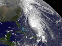
NOAA's GOES-14 satellite captured a visible image of Tropical Storm Rafael in the Atlantic on Oct. 16 at 7:45 a.m. EDT. The image shows the extent of Hurricane Rafael, which is over 410 miles in diameter.
That's longer than the distance between Boston and Washington, D.C. The visible image also showed a thick row of clouds northwest of Rafael. Those clouds are associated with a cold front that just moved off the U.S. east coast and they will play a role in pushing Rafael to the east and draw Rafael into the front.
Infrared satellite data also revealed that the coldest cloud top temperatures (indicating the highest cloud tops and strongest thunderstorms) shifted west of Rafael's center. Those strongest thunderstorms and coldest cloud tops appear as the brightest white area of clouds in the storm on the GOES-14 image.
GOES-14 is operated by NOAA, and the image was created by the NASA GOES Project at NASA's Goddard Space Flight Center, Greenbelt, Md.
A tropical storm warning is in effect for Bermuda today, Oct. 16. The National Hurricane Center (NHC) expects that Bermuda will see between 2 and 4 inches of rainfall and tropical-storm-force winds. NHC expects the center of Rafael to pass east of Bermuda by this evening. Rafael will continue generating rough surf in Bermuda, eastern-facing beaches of the Bahamas and portions of the United States east coast during the next couple of days.
At 8 a.m. EDT on Oct. 16, Rafael's center was near latitude 27.3 north and longitude 65.0 west. Rafael was moving toward the north-northeast near 16 mph (26 kph) and is forecast to turn toward the northeast later on Oct. 16. Rafael's maximum sustained winds were near 85 mph (140 kph), making the storm a category one hurricane on the Saffir-Simpson Hurricane wind scale.
According to the NHC discussion, Rafael is expected to be over much colder water and merge with the strong cold front seen in the GOES-14 satellite image from today, Oct. 16. The merging of systems should cause Rafael to transition into a large and powerful extra-tropical low that will move eastward over the far north Atlantic.
Media Contact
More Information:
http://www.nasa.govAll latest news from the category: Earth Sciences
Earth Sciences (also referred to as Geosciences), which deals with basic issues surrounding our planet, plays a vital role in the area of energy and raw materials supply.
Earth Sciences comprises subjects such as geology, geography, geological informatics, paleontology, mineralogy, petrography, crystallography, geophysics, geodesy, glaciology, cartography, photogrammetry, meteorology and seismology, early-warning systems, earthquake research and polar research.


Newest articles

Properties of new materials for microchips
… can now be measured well. Reseachers of Delft University of Technology demonstrated measuring performance properties of ultrathin silicon membranes. Making ever smaller and more powerful chips requires new ultrathin…

Floating solar’s potential
… to support sustainable development by addressing climate, water, and energy goals holistically. A new study published this week in Nature Energy raises the potential for floating solar photovoltaics (FPV)…

Skyrmions move at record speeds
… a step towards the computing of the future. An international research team led by scientists from the CNRS1 has discovered that the magnetic nanobubbles2 known as skyrmions can be…

