Satellite sees Hurricane Fabio still chasing Emilia's remnants in Pacific Ocean
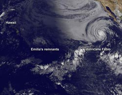
This image was taken on July 16, 2012, at 1500 UTC (11 a.m. EDT) from the GOES-15 satellite. It shows the remnants of Hurricane Emilia southeast of Hawaii, and Hurricane Fabio far to the east. Emilia is seen by infrared imagery because the storm is in darkness, while Fabio is seen in visible light. Credit: Credit: NASA GOES Project<br>
Emilia's remnants appear as a light swirl of clouds on satellite imagery from NOAA's GOES-15 satellite. GOES-15 sits in a fixed orbit over the western U.S. and provides weather imagery. In an image from July 16 at 1500 UTC (11 a.m. EDT) while Hawaii was still in the pre-dawn hours, infrared imagery on GOES-15 captured the ghostly image of Hurricane Emilia's remnants.
Those remnants were about 800 miles east-southeast of Hilo and are moving to the west at close to 20 mph. The National Hurricane Center noted that conditions are not favorable for re-development.
Meanwhile, the showstopper continues to be Hurricane Fabio, although now weaker than it was over the weekend. Fabio is in the daylight and is shown in GOES-15 visible imagery. Both the infrared and visible imagery were combined by NASA's GOES Project, located at the NASA Goddard Space Flight Center in Greenbelt, Md. NOAA manages the GOES satellites, but NASA's GOES project creates images and animations.
At 11 a.m. EDT on July 16, Fabio took a northwesterly turn. Fabio is now headed northwest at 8 mph (13 kmh) and is expected to turn to the north over the next couple of days, according to the National Hurricane Center. Fabio is also moving into cooler waters which is expected to weaken the tropical cyclone down to depression status. Fabio's maximum sustained winds were still near 75 mph (120 kmh) at 11 a.m. EDT. Fabio was centered near 18.9 North and 119.9 West, about 700 miles (1,130 km) west-southwest of the southern tip of Baja California.
As Fabio continues to move closer to Baja California, ocean swells and rip currents are a concern along the coast there as well as in southern California.
Media Contact
More Information:
http://www.nasa.govAll latest news from the category: Earth Sciences
Earth Sciences (also referred to as Geosciences), which deals with basic issues surrounding our planet, plays a vital role in the area of energy and raw materials supply.
Earth Sciences comprises subjects such as geology, geography, geological informatics, paleontology, mineralogy, petrography, crystallography, geophysics, geodesy, glaciology, cartography, photogrammetry, meteorology and seismology, early-warning systems, earthquake research and polar research.


Newest articles

Properties of new materials for microchips
… can now be measured well. Reseachers of Delft University of Technology demonstrated measuring performance properties of ultrathin silicon membranes. Making ever smaller and more powerful chips requires new ultrathin…

Floating solar’s potential
… to support sustainable development by addressing climate, water, and energy goals holistically. A new study published this week in Nature Energy raises the potential for floating solar photovoltaics (FPV)…

Skyrmions move at record speeds
… a step towards the computing of the future. An international research team led by scientists from the CNRS1 has discovered that the magnetic nanobubbles2 known as skyrmions can be…

