Satellite Imagery Hints That Tropical Depression 7 May Be Reborn
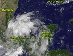
On August 17, 2012, NOAA's GOES-13 satellite captured visible images of Tropical Depression 7's remnants at 9:45 a.m. EDT. Showers and thunderstorm activity has increased over the Bay of Campeche.<br>Credit: NASA GOES Project <br>
NASA's GOES Project created a visible image of the remnants of Tropical Depression 7 from August 17 at 9:45 a.m. EDT (1345 UTC) from NOAA's GOES-13 satellite. The image showed several areas of stronger thunderstorms. The stronger thunderstorms appear brighter white in the imagery and are located around the center and to the northeast of the center of circulation. NASA's GOES Project is located at the NASA Goddard Space Flight Center in Greenbelt, Md.
The Bay of Campeche is located on the western side of Mexico's Yucatan Peninsula, and is part of the southwestern Gulf of Mexico. The Bay is surrounded on three sides by the Mexican states of Campeche, Veracruz and Tabasco.
Shower and thunderstorm activity picked up during the morning hours (Eastern Daylight Time) on August 17 in the southwestern Gulf of Mexico and Bay of Campeche. The National Hurricane Center (NHC) noted “surface observations and radar data indicate that the circulation has also become a little better defined and environmental conditions appear conducive for development.”
The remnants of TD7 are moving to the west-northwestward to northwestward at around 10 mph.
The NHC stated that a tropical depression could re-form before the low pressure area makes another landfall in Mexico over the weekend. So the remnants have a 70 percent chance of becoming a tropical depression again. A tropical storm watch or warning could be needed for part of the Gulf coast of Mexico.
Text Credit: Rob Gutro
NASA Goddard Space Flight Center, Greenbelt, Md.
Media Contact
All latest news from the category: Earth Sciences
Earth Sciences (also referred to as Geosciences), which deals with basic issues surrounding our planet, plays a vital role in the area of energy and raw materials supply.
Earth Sciences comprises subjects such as geology, geography, geological informatics, paleontology, mineralogy, petrography, crystallography, geophysics, geodesy, glaciology, cartography, photogrammetry, meteorology and seismology, early-warning systems, earthquake research and polar research.


Newest articles

Bringing bio-inspired robots to life
Nebraska researcher Eric Markvicka gets NSF CAREER Award to pursue manufacture of novel materials for soft robotics and stretchable electronics. Engineers are increasingly eager to develop robots that mimic the…

Bella moths use poison to attract mates
Scientists are closer to finding out how. Pyrrolizidine alkaloids are as bitter and toxic as they are hard to pronounce. They’re produced by several different types of plants and are…

AI tool creates ‘synthetic’ images of cells
…for enhanced microscopy analysis. Observing individual cells through microscopes can reveal a range of important cell biological phenomena that frequently play a role in human diseases, but the process of…

