Satellite Data Shows a Very Active Tropical Atlantic, Gabrielle Weakens
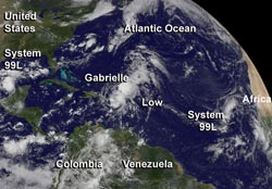
NOAA's GOES-East satellite captured a view of System 99L (far left), Gabrielle, an unnamed system east of it, and System 98L (far right) on Sept. 5 at 10:45 a.m. EDT. <br><br>Image Credit: NASA GOES Project<br>
NOAA's GOES-East satellite captured a view of Gabrielle, an unnamed system east of it, and Systems 99L and 98L on Sept. 5 at 10:45 a.m. EDT. NOAA's GOES-East satellite captured all four systems in a view across the entire Atlantic Ocean. The image was created by NASA's GOES Project at NASA's Goddard Space Flight Center in Greenbelt, Md.
At 11 a.m. EDT on Sept. 5, Tropical Depression Gabrielle's maximum sustained winds dropped to near 35 mph/55 kph, when it was centered just about 80 miles/125 km south-southeast of Punta Cana, Dominican Republic near 17.5 north and 68.1 west. Gabrielle was moving to the northwest at 9 mph/15 kph. New data from the National Hurricane Center indicates that Gabrielle is not expected to intensify and may lose tropical cyclone status in the next day or two after it moves over the Dominican Republic tonight, Sept. 5. A tropical storm watch is in effect for the Dominican Republic from Cabo Engano to Cabo Frances Viejo.
When NASA's Aqua satellite passed over Gabrielle earlier on Sept. 5 at 1:41 a.m. EDT, it was a tropical storm. Gabrielle's cloud top temperatures were as cold as -63F/-52C at that time, and have since warmed. Warming cloud top temperatures indicate that cloud heights have dropped and there's not as much punch or uplift in the atmosphere. When Aqua passed by, the Atmospheric Infrared Sounder or AIRS instrument captured an infrared image that showed thunderstorms with cold cloud tops over Puerto Rico. Those thunderstorms had the capability of dropping heavy rainfall.
NASA's HS3 Investigates Gabrielle
One of two of NASA's Global Hawks flew over Tropical Depression Seven on Sept. 4, which organized into Tropical Storm Gabrielle. The Global Hawk deployed a record 80 dropsondes during the mission. The next two Global Hawk flights are expected to occur over Tropical Storm Gabrielle over the weekend of Sept. 7 and 8. NASA 872 may fly over Gabrielle on Saturday, Sept. 7 and NASA 871 may investigate the tropical storm on Sunday, Sept. 8 if Gabrielle holds together.
Despite being downgraded, Gabrielle is still expected to produce copious amounts of rainfall. Gabrielle is expected to drop between 2 to 4 inches over Puerto Rico and the U.S. Virgin Islands with isolated maximum amounts of up to 8 inches possible in areas of mountainous terrain.
A Low East of Gabrielle
Just to the east of Gabrielle is a large, elongated low pressure area (or trough) that does not yet have an investigation number assigned to it. It is centered near 21 north and 62 west and contains disorganized showers and thunderstorms. This low extends from the northeastern Leeward Islands northeastward over the Atlantic waters for several hundred miles. Because it is close to Gabrielle, development of this low is expected to be slow. The National Hurricane Center has given this area just a 20 percent chance of development in the next two days.
System 99L
One low pressure area that does have a designation is in the southwestern Gulf of Mexico. That low is also elongated (a trough) ad has associated showers and thunderstorms. However, this low, designated as System 99L is only possible before it moves inland along the coast of mainland Mexico on Friday, Sept. 6. This system has a medium chance of becoming a tropical cyclone during the next two days.
System 98L
Far in the eastern Atlantic lies System 98L, about 450 miles west-southwest of the Cape Verde Islands near 13.8 north and 31.3 west. This system has showers and thunderstorms that are showing some signs of organization. Dry air in the region, however, is expected to limit development potential, so this low has a low chance of becoming a tropical depression in the next couple of days.
Text credit: Rob Gutro
NASA's Goddard Space Flight Center
Media Contact
All latest news from the category: Earth Sciences
Earth Sciences (also referred to as Geosciences), which deals with basic issues surrounding our planet, plays a vital role in the area of energy and raw materials supply.
Earth Sciences comprises subjects such as geology, geography, geological informatics, paleontology, mineralogy, petrography, crystallography, geophysics, geodesy, glaciology, cartography, photogrammetry, meteorology and seismology, early-warning systems, earthquake research and polar research.


Newest articles

Properties of new materials for microchips
… can now be measured well. Reseachers of Delft University of Technology demonstrated measuring performance properties of ultrathin silicon membranes. Making ever smaller and more powerful chips requires new ultrathin…

Floating solar’s potential
… to support sustainable development by addressing climate, water, and energy goals holistically. A new study published this week in Nature Energy raises the potential for floating solar photovoltaics (FPV)…

Skyrmions move at record speeds
… a step towards the computing of the future. An international research team led by scientists from the CNRS1 has discovered that the magnetic nanobubbles2 known as skyrmions can be…

