Getting ready for the ’big one,’ researchers make most detailed survey ever of San Adreas Fault
Images show never-before-seen fault lines – plus cows, trees
Researchers have completed the most meticulous survey ever made of the San Andreas Fault, and they’ve found detailed features that nobody could have seen before.
Michael Bevis, Ohio Eminent Scholar in geodynamics and professor of civil and environmental engineering and geodetic science at Ohio State University, unveiled the first images from the ambitious new survey Wednesday at the American Geophysical Union meeting in San Francisco.
His team will spend the next year processing the rest of the survey data, which they gathered using ultra-high-resolution global positioning system (GPS) technology and a radar-like system called lidar.
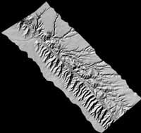
Short for “light detection and ranging,” lidar measures the time it takes for light to reflect off the surface of an object. The combined GPS and lidar technologies enabled the researchers to map the surface of the San Andreas Fault with 5-centimeter (1.97 inches) vertical resolution.
The researchers dubbed their survey the “B4” Project, because the data will form the “before” images that scientists will compare to “after” images of the next big San Andreas earthquake when it inevitably happens.
Scientists know more or less what happens away from a fault line during an earthquake, Bevis said. But what happens near or in the fault, or how an earthquake starts – these things are not well known, and are frequently debated among scientists.
“By having this high resolution image of before and after a quake, we should be able to resolve some of these debates,” Bevis said.
They loaded their equipment on board a twin-engine Cessna airplane, and covered nearly 1,000 kilometers (621.37 miles) of the fault in two months of flights, during May and August of 2005.
Bevis recalled that the flights required near-heroic effort from the team pilots. “We had to fly low and closely manage the orientation of the aircraft at all times so we knew exactly where the laser on the lidar instrument was pointing,” he said.
A less-controlled airborne photographic survey would have been easier, but also much more time consuming. “To do this kind of survey the traditional way would take years – just to process the photographs. We’ll have preliminary results in a month, and refined results in six months,” Bevis said.
The San Andreas fault splits in the south, with one of the two offshoots becoming the San Jacinto Fault. The B4 Survey covered both, tracing the main fault lines and countless smaller lines branching from them.
Looking at one of the images, Bevis easily picked out the SUV belonging to team members who drove along the fault ahead of the plane. Even the tripod holding one of their portable GPS stations was visible. He identified other dots on the image as cows and small trees.
How could he tell which ones were cows? “When we looked back later, some of them had moved,” he said.
The team will post its maps on the Web. “As we do each day’s processing, we’ll make it available to the whole scientific community,” Bevis said. “People are going to find all kinds of faults and other features that they never knew about before.
“Often a fault line is fairly subtle,” he continued. “There are some spots where, if you were actually standing on the ground, and you weren’t a geologist who knows the area really well, you probably couldn’t even see it. But in these images you can.”
Scientists anticipate that a “Big One” – an earthquake of magnitude 8 or more on the Richter scale – will eventually strike California via the San Andreas. The 1906 San Francisco Earthquake was blamed on the fault, and scientists believe it would have registered near magnitude 8, had the scale existed then. But when another Big One will strike is an open question.
As detailed as the new survey is, Bevis said it can’t be used to predict the future.
“The point of the B4 Project is to learn more about earthquakes in general,” he said. “People think we may one day find a way to predict earthquakes, but I think it may be impossible. Not all processes are predictable.”
Media Contact
More Information:
http://www.osu.eduAll latest news from the category: Earth Sciences
Earth Sciences (also referred to as Geosciences), which deals with basic issues surrounding our planet, plays a vital role in the area of energy and raw materials supply.
Earth Sciences comprises subjects such as geology, geography, geological informatics, paleontology, mineralogy, petrography, crystallography, geophysics, geodesy, glaciology, cartography, photogrammetry, meteorology and seismology, early-warning systems, earthquake research and polar research.


Newest articles

Properties of new materials for microchips
… can now be measured well. Reseachers of Delft University of Technology demonstrated measuring performance properties of ultrathin silicon membranes. Making ever smaller and more powerful chips requires new ultrathin…

Floating solar’s potential
… to support sustainable development by addressing climate, water, and energy goals holistically. A new study published this week in Nature Energy raises the potential for floating solar photovoltaics (FPV)…

Skyrmions move at record speeds
… a step towards the computing of the future. An international research team led by scientists from the CNRS1 has discovered that the magnetic nanobubbles2 known as skyrmions can be…

