Satellites Record Weakening North Atlantic Current
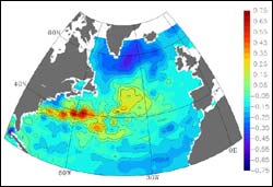
Dominant Pattern of Variability of the Sea-surface Height in the 1990s <br> <br>This image shows the dominant pattern of variability of the sea-surface height in the 1990s. The slope of the sea-surface height is in balance with ocean currents, much in the way weather maps of pressure relate to winds. The large blue region in the northern Atlantic represents a slowing of the counter-clockwise, <br>cyclonically circulating subpolar gyre. For this image, the researchers used TOPEX/Poseidon data, which has been combined with ERS-1/2 data into the NASA Pathfinder data set. The Pathfinder data set also includes the Seasat and Geosat data which are referenced to TOPEX/Poseidon data. The next few years will reveal how sea surface height is going to evolve as the altimetric time series continues with JASON-1 observations. Credit: Sirpa Hakkinen, NASA GSFC <br>
A North Atlantic Ocean circulation system weakened considerably in the late 1990s, compared to the 1970s and 1980s, according to a NASA study.
Sirpa Hakkinen, lead author and researcher at NASA’s Goddard Space Flight Center, Greenbelt, Md. and co-author Peter Rhines, an oceanographer at the University of Washington, Seattle, believe slowing of this ocean current is an indication of dramatic changes in the North Atlantic Ocean climate. The study’s results about the system that moves water in a counterclockwise pattern from Ireland to Labrador were published on the Internet by the journal Science on the Science Express Web site at:
http://www.sciencexpress.org or http://www.aaas.org
The current, known as the sub polar gyre, has weakened in the past in connection with certain phases of a large-scale atmospheric pressure system known as the North Atlantic Oscillation (NAO). But the NAO has switched phases twice in the 1990s, while the subpolar gyre current has continued to weaken. Whether the trend is part of a natural cycle or the result of other factors related to global warming is unknown.
“It is a signal of large climate variability in the high latitudes,” Hakkinen said. “If this trend continues, it could indicate reorganization of the ocean climate system, perhaps with changes in the whole climate system, but we need another good five to 10 years to say something like that is happening.” Rhines said, “The subpolar zone of the Earth is a key site for studying the climate. It’s like Grand Central Station there, as many of the major ocean water masses pass through from the Arctic and from warmer latitudes. They are modified in this basin. Computer models have shown the slowing and speeding up of the subpolar gyre can influence the entire ocean circulation system.”
Satellite data makes it possible to view the gyre over the entire North Atlantic basin. Measurements from deep in the ocean, using buoys, ships and new autonomous “robot” Seagliders, are important for validating and extending the satellite data. Sea-surface height satellite data came from NASA’s Seasat (July, August 1978), U.S. Navy’s Geosat (1985 to 1988), and the European Space Agency’s European Remote Sensing Satellite1/2 and NASA’s TOPEX/Poseidon (1992 to present).
Hakkinen and Rhines were able to reference earlier data to TOPEX/Poseidon data, and translate the satellite sea-surface height data to velocities of the subpolar gyre. The subpolar gyre can take 20 years to complete its route. Warm water runs northward through the Gulf Stream, past Ireland, before it turns westward near Iceland and the tip of Greenland.
The current loses heat to the atmosphere as it moves north. Westerly winds pick up that lost heat, creating warmer, milder European winters. After frigid Labrador Sea winters, the water in the current becomes cold, salty and dense, plunges beneath the surface, and heads slowly southward back to the equator. The cycle is sensitive to the paths of winter storms and to the buoyant fresh water from glacial melting and precipitation, all of which are experiencing great change.
While previous studies have proposed winds resulting from the NAO have influenced the subpolar gyre’s currents, this study found heat exchanges from the ocean to the atmosphere may be playing a bigger role in the weakening current. Using Topex/Poseidon sea-surface height data, the researchers inferred Labrador Sea water in the core of the gyre warmed during the 1990s. This warming reduces the contrast with water from warmer southern latitudes, which is part of the driving force for ocean circulation.
The joint NASA-CNES (French Space Agency) Topex/Poseidon oceanography satellite provides high-precision data on the height of the world’s ocean surfaces, a key measure of ocean circulation and heat storage in the ocean.
NASA’s Earth Science Enterprise is dedicated to understanding the Earth as an integrated system and applying Earth System Science to improve prediction of climate, weather and natural hazards using the unique vantage point of space. NASA, the National Oceanic and Atmospheric Administration, and the National Science Foundation funded the study.
Media Contact
More Information:
http://www.gsfc.nasa.gov/topstory/2004/0415gyre.htmlAll latest news from the category: Earth Sciences
Earth Sciences (also referred to as Geosciences), which deals with basic issues surrounding our planet, plays a vital role in the area of energy and raw materials supply.
Earth Sciences comprises subjects such as geology, geography, geological informatics, paleontology, mineralogy, petrography, crystallography, geophysics, geodesy, glaciology, cartography, photogrammetry, meteorology and seismology, early-warning systems, earthquake research and polar research.


Newest articles

Silicon Carbide Innovation Alliance to drive industrial-scale semiconductor work
Known for its ability to withstand extreme environments and high voltages, silicon carbide (SiC) is a semiconducting material made up of silicon and carbon atoms arranged into crystals that is…

New SPECT/CT technique shows impressive biomarker identification
…offers increased access for prostate cancer patients. A novel SPECT/CT acquisition method can accurately detect radiopharmaceutical biodistribution in a convenient manner for prostate cancer patients, opening the door for more…

How 3D printers can give robots a soft touch
Soft skin coverings and touch sensors have emerged as a promising feature for robots that are both safer and more intuitive for human interaction, but they are expensive and difficult…

