NASA Joins Snow Study Over The Sea Of Japan
NASA and two Japanese government agencies are collaborating on a snowfall study over Wakasa Bay, Japan. Using NASA’s Earth Observing System Aqua satellite, research aircraft and coastal radars to gather data, the joint effort is expanding scientific knowledge about where precipitation falls.
Until now, the north Pacific’s contributions to the global hydrologic cycle have been difficult to quantify. Precipitation measurements by satellite over open water are very important, because there are very few other ways to obtain the data. Snowfall is particularly difficult to measure from space even over the relatively uniform background of the ocean. New satellite instruments, that can detect precipitation over water, will give scientists data to help interpret how the hydrology of the Pacific Ocean impacts the U.S. and the world.
The Wakasa Bay Field Campaign is a combined research effort among NASA, the National Space Agency of Japan (NASDA), and the Japanese Meteorological Research Institute (MRI). The campaign began January 3 and runs through February 14.
“These experiments are critical to understanding whether the current El Nino event, for instance, actually increases global precipitation or merely redistributes it between land and ocean regions,” said Tom Wilheit, Mission Scientist from Texas A&M University.
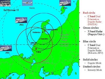
Wakasa Bay, located North of Osaka on the Sea of Japan, is known for its diverse weather in winter months. Ranging from extreme cold, that brings Siberian air and accompanying snow into the region, to fast moving extra-tropical low pressure systems, that consist primarily of rain at the surface, but originating as snowfall at higher altitudes.
A NASA P-3 Orion aircraft, from Wallops Island, Va., is flying over the bay and collecting data on snowfall and rainfall to compare to data being gathered by the Aqua satellite orbiting over the same area. The aircraft payload consists of five microwave sensors, each capable of uniquely observing precipitation and cloud properties.
On board Aqua is a Japanese-built Advanced Microwave Scanning Radiometer-Earth Observing System (AMSR-E) instrument. “With AMSR-E on Aqua, we’re able to extend the high quality precipitation measurements from the Tropical Rainfall Measuring Mission satellite to beyond the tropics, in fact into both the mid-and high latitudes,” said Claire Parkinson, Aqua Project Scientist at NASA’s Goddard Space Flight Center, Greenbelt, Md.
Some of the measurements will also be used for another field campaign concerning sea ice in the Sea of Okhotsk and to compare with data from the AMSR instrument aboard the Japanese ADEOS-II satellite.
The Wakasa Bay experiment is designed to test the calculations and methods that scientists use to process satellite data. The P-3 Orion observations will be used to get precise values for the cloud and precipitation properties, such as the size distribution of the ice particles or raindrops, that are currently assumed in the satellite calculations. By replacing the assumed data with precise observations from the P-3, scientists can determine the accuracy of the Aqua AMSR-E rainfall and snowfall estimates.
“This mission will be helpful in understanding the north Pacific, because there is simply no place in this vast stretch of ocean where surface observations can be taken.
Despite its remoteness, the ocean’s size makes it an important player in the global hydrologic cycle that must be properly quantified to make progress in the global sense,” said Christian Kummerow, Atmospheric Scientist at Colorado State University, Boulder, Co., one of the leaders of this mission.
NASA’s Aqua satellite was launched on May 4, 2002. The Aqua mission provides a multi-disciplinary study of the Earth’s atmospheric, oceanic, cryospheric, and land processes and their relationship to global change.
For the AMSR-E instrument website:
http://aqua.nasa.gov/AMSRE3.html
Media Contact
All latest news from the category: Earth Sciences
Earth Sciences (also referred to as Geosciences), which deals with basic issues surrounding our planet, plays a vital role in the area of energy and raw materials supply.
Earth Sciences comprises subjects such as geology, geography, geological informatics, paleontology, mineralogy, petrography, crystallography, geophysics, geodesy, glaciology, cartography, photogrammetry, meteorology and seismology, early-warning systems, earthquake research and polar research.


Newest articles

Silicon Carbide Innovation Alliance to drive industrial-scale semiconductor work
Known for its ability to withstand extreme environments and high voltages, silicon carbide (SiC) is a semiconducting material made up of silicon and carbon atoms arranged into crystals that is…

New SPECT/CT technique shows impressive biomarker identification
…offers increased access for prostate cancer patients. A novel SPECT/CT acquisition method can accurately detect radiopharmaceutical biodistribution in a convenient manner for prostate cancer patients, opening the door for more…

How 3D printers can give robots a soft touch
Soft skin coverings and touch sensors have emerged as a promising feature for robots that are both safer and more intuitive for human interaction, but they are expensive and difficult…

