Phillipines Get a Soaking from Haiyan and Tropical Storm 30W
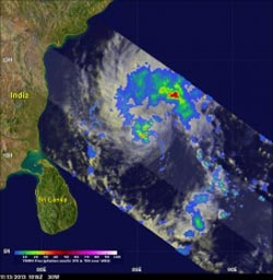
TRMM satellite view of rainfall with the newly energized tropical disturbance in the Bay of Bengal on November 13, 2013 at 10:15 UTC. <br>Image Credit: Hal Pierce, SSAI/NASA GSFC <br>
The combined rainfall from these tropical cyclones is shown in the TRMM-based, near-real time Multi-satellite Precipitation data (TMPA) analysis shown above during the period from November 2-12, 2013 (first image to the right).
It shows that most of the island of Leyte had rainfall totals greater than 500mm (~19.7 inches, dark red) with a peak amount of over 685 mm (~27 inches, lighter purple) located over the southeast corner of the island.
Peak and average rainfall over the central Philippines (second image to the right) shows that despite being far less intense, Tropical Storm Thirty, which preceded Super Typhoon Haiyan by about three days, produced similar peak rain intensities (shown in red) and over a similar duration, but less average rainfall (shown in blue) than Haiyan.
The remnants of what was once Tropical Storm Thirty (30W) over the Philippines have made there way into the Bay of Bengal after dropping heavy rainfall over Indochina.
Tropical Depression 30W (Thirty) is now poised to bring rainfall to parts of India.
The image on the left shows a TRMM satellite view of rainfall with the newly energized tropical disturbance in the Bay of Bengal on November 13, 2013 at 10:15 UTC. TRMM's Microwave Imager (TMI) and Precipitation Radar (PR) instruments found rain falling at a rate of over 81 mm/hr (~3.2 inches) in convective storms at 11.0N 85.2W near the center of the tropical disturbance. The image on the right shows a 3-D view of 30W using data from TRMM's Precipitation Radar (PR) instrument. TRMM's PR found that a few of the powerful convective storms near the center of the tropical depression were reaching heights of 15.5 km (~9.6 miles).
TRMM is a joint mission between NASA and the Japanese space agency JAXA.
Text credit: Hal Pierce and Steve Lang, SSAI/NASA GSFC
NASA's Goddard Space Flight Center
Media Contact
All latest news from the category: Earth Sciences
Earth Sciences (also referred to as Geosciences), which deals with basic issues surrounding our planet, plays a vital role in the area of energy and raw materials supply.
Earth Sciences comprises subjects such as geology, geography, geological informatics, paleontology, mineralogy, petrography, crystallography, geophysics, geodesy, glaciology, cartography, photogrammetry, meteorology and seismology, early-warning systems, earthquake research and polar research.


Newest articles

Superradiant atoms could push the boundaries of how precisely time can be measured
Superradiant atoms can help us measure time more precisely than ever. In a new study, researchers from the University of Copenhagen present a new method for measuring the time interval,…

Ion thermoelectric conversion devices for near room temperature
The electrode sheet of the thermoelectric device consists of ionic hydrogel, which is sandwiched between the electrodes to form, and the Prussian blue on the electrode undergoes a redox reaction…

Zap Energy achieves 37-million-degree temperatures in a compact device
New publication reports record electron temperatures for a small-scale, sheared-flow-stabilized Z-pinch fusion device. In the nine decades since humans first produced fusion reactions, only a few fusion technologies have demonstrated…

