New atlas provides highest-resolution imagery of the Polar Regions seafloor
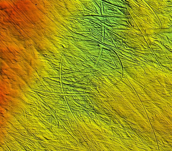
An almost circular iceberg ploughmark from south of Brasvelbreen, Svalbard. Red 25 m water depth, green 50 m. Credit: Atlas of Submarine Glacial Landforms (2017)
Thousands of square kilometres of the seafloor, covering an area the size of Great Britain, showcase a range of geological phenomena such as plough marks, scratched on the seafloor by the underwater keels of huge icebergs, and glacial lineations – streamlined ridges up to tens of kilometres long moulded on the beds of fast-flowing glaciers.
More than 35 individual landforms feature and are described, ranging from dramatic features in the East Siberian permafrost to trough-mouth fans – enormous sediment deposits that build up at the mouths of the largest glaciers. The scientists examine the “fingerprint” of past glaciers and ice sheets on the seafloor where they have previously advanced and retreated due to changes in the Earth's climate.
Dr Kelly Hogan, a geophysicist at British Antarctic Survey (BAS) and an editor of the volume, is presenting the atlas at the EGU in Vienna. She says:
“It's exciting to see the atlas finally in print. It's a huge achievement to bring together all these images in a way that will enable us to interpret the polar seafloor landscape like never before. And it's a beautiful representation of what the seafloor can tell us about the past, much like a tree ring. For the first time it brings together examples of the more widely known glacial landforms. For example mega-scale glacial lineations offshore the Antarctic Peninsula but also of rare, enigmatic features like 40 km-long needle-shaped ridges in the Barents Sea and frost polygons – raised mounds with geometric patterns – formed in a permafrost landscape (then submerged by the sea) in the Laptev Sea, Eastern Siberia.
“The value in having these beautiful exemplars in one volume is that we can now compare features from a range of locations and climatic settings (mild to extreme cold) and gain key information on past ice dynamics and ice retreat.”
Advances in ice-breaking research vessels and the use of state-of-the-art acoustic methods have produced high-resolution seafloor imagery from water depths of tens to thousands of metres, presenting it in a three dimensional context.
Lead Editor Professor Julian Dowdeswell, who is the Director of the Scott Polar Research Institute in Cambridge University, says:
“The individual glacial landforms and groups of landforms presented in the atlas cover a wide geographic spread from the coldest environments on the planet in East Antarctica to the warmest areas where ice reaches the sea like the fjords of Chile or Alaska. Most examples in the atlas were created since the last glacial about 20 000 years ago, but it also includes landforms from “ancient” glaciations. For example, glacial lineations that are several kilometres long are found across the Murzuq Basin in Libya, formed by an ice sheet that grew over Africa around 450 million years ago when the continent was sitting over the South Pole. These “ancient” glacial landforms are strikingly similar to the features we see on the seafloor around Antarctica today that were made by an expanded Antarctic Ice Sheet during the last glacial cold period.”
The atlas is presented at a session at the EGU 2017 science conference in Vienna, Austria on Wednesday 26 April. It was published recently as Memoir 46 of the Geological Society of London.
###
Issued by the British Antarctic Survey Press Office:
Dr Kelly Hogan will present the atlas at a press conference in the media centre at EGU. Polar Regions: Arctic sea-ice future, Antarctic ice-shelf stability, and glacial landforms takes place on Tuesday 25 April, 10.00 – 11.00. For media enquiries at EGU please contact: Athena Dinar, Senior PR & Communications Manager, British Antarctic Survey, tel: +44 (0)1223 221 441; mobile: +44 (0)7909 008516; email: amdi@bas.ac.uk
Other media enquiries to Jon Fuhrmann, British Antarctic Survey, tel: +44 (0)1223 221 506; mobile: +44 (0) 7850 541911: jonann@bas.ac.uk
Notes to Editors:
In an unprecedented international collaboration, scientists from 75 institutions across 20 countries have combined their expertise and knowledge of glaciers and their interaction with the seafloor. The atlas contains more than 200 seafloor images as well as seafloor photographs. It is the first volume of its kind for 20 years and images glacial landforms up to five times smaller than was possible before modern acoustic mapping techniques were developed.
Geological Society website: https:/
Lyell Collection: http://mem.
The Geological Society of London, founded in 1807, is a learned and professional body of over 12,000 Earth scientists with a remit to investigate, interpret, discuss, inform and advise on the nature and processes of the Earth, their practical importance to humanity, and, in the interests of the public, to promote professional excellence. The Society offers advice to Parliament and Government, at individual and corporate levels. Registered Charity No. 210161.
The Geological Society Publishing House publishes over 280,000 peer-reviewed pages in the Lyell Collection Complete, which includes seven journals, over 425 special publications, Engineering Geology Special Publications, 47 Memoirs and five Petroleum Geology Conference Proceedings. http://www.
British Antarctic Survey (BAS), an institute of the Natural Environment Research Council (NERC), delivers and enables world-leading interdisciplinary research in the Polar Regions. Its skilled science and support staff based in Cambridge, Antarctica and the Arctic, work together to deliver research that uses the Polar Regions to advance our understanding of Earth as a sustainable planet. Through its extensive logistic capability and know-how BAS facilitates access for the British and international science community to the UK polar research operation. Numerous national and international collaborations, combined with an excellent infrastructure help sustain a world leading position for the UK in Antarctic affairs. For more information visit http://www.
The Scott Polar Research Institute (SPRI) is part of the University of Cambridge. It is an international centre for research into the Polar Regions and is also home to unrivalled resources of polar information and expertise, housing the world's largest polar library, Britain's only dedicated polar museum, and a national repository for polar archives that record some of the most memorable episodes in exploration of the Arctic and Antarctic. For more information visit http://www.
Media Contact
All latest news from the category: Earth Sciences
Earth Sciences (also referred to as Geosciences), which deals with basic issues surrounding our planet, plays a vital role in the area of energy and raw materials supply.
Earth Sciences comprises subjects such as geology, geography, geological informatics, paleontology, mineralogy, petrography, crystallography, geophysics, geodesy, glaciology, cartography, photogrammetry, meteorology and seismology, early-warning systems, earthquake research and polar research.


Newest articles

Superradiant atoms could push the boundaries of how precisely time can be measured
Superradiant atoms can help us measure time more precisely than ever. In a new study, researchers from the University of Copenhagen present a new method for measuring the time interval,…

Ion thermoelectric conversion devices for near room temperature
The electrode sheet of the thermoelectric device consists of ionic hydrogel, which is sandwiched between the electrodes to form, and the Prussian blue on the electrode undergoes a redox reaction…

Zap Energy achieves 37-million-degree temperatures in a compact device
New publication reports record electron temperatures for a small-scale, sheared-flow-stabilized Z-pinch fusion device. In the nine decades since humans first produced fusion reactions, only a few fusion technologies have demonstrated…

