NASA Watches as India Braces for Tropical Cyclone Lehar
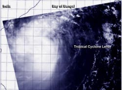
The MODIS instrument aboard NASA's Aqua satellite captured this visible image of Tropical Cyclone Lehar nearing the coast of central India on Nov. 27 at 0715 UTC. <br>Image Credit: NRL-Monterey/NASA<br>
Warnings were in effect in India for northern Andhra Pradesh and southern Odisha as Lehar approaches. Lehar will bring winds, heavy rainfall and storm surge to those Indian states today, and tomorrow. A storm surge of up to 3 meters is possible.
The MODIS instrument aboard NASA's Aqua satellite captured a visible image of Tropical Cyclone Lehar nearing the coast of central India on Nov. 27 at 0715 UTC/2:15 a.m. EST. The MODIS image showed bands of thunderstorms extending from the northern and southern quadrants of the storm, wrapping into the center. There was no visible eye, despite Lehar being at minimal hurricane-strength.
At 1500 UTC/10 a.m. EST on November 27, Lehar's maximum sustained winds were near 55 knots/63.2 mph/101.9 kph. Tropical-storm-force winds extended out 105 nautical miles/120.8 miles/194.5 km from the center of circulation, and the center was about 195 nautical miles southeast of Visakhapatnam, India. That puts the center near 15.1 north and 84.2 east. Lehar is generating high and rough seas with wave heights to 24 feet/7.3 meters as it moves to the west-northwest at 12 knots/13.8 mph/22.2 kph.
The Joint Typhoon Warning Center expects Lehar to strengthen a little more before making landfall in eastern India on November 27 at 0700 UTC/2 a.m. EST. By November 28 Lehar is expected to dissipate.
Text credit: Rob Gutro
NASA's Goddard Space Flight Center
Media Contact
All latest news from the category: Earth Sciences
Earth Sciences (also referred to as Geosciences), which deals with basic issues surrounding our planet, plays a vital role in the area of energy and raw materials supply.
Earth Sciences comprises subjects such as geology, geography, geological informatics, paleontology, mineralogy, petrography, crystallography, geophysics, geodesy, glaciology, cartography, photogrammetry, meteorology and seismology, early-warning systems, earthquake research and polar research.


Newest articles

Bringing bio-inspired robots to life
Nebraska researcher Eric Markvicka gets NSF CAREER Award to pursue manufacture of novel materials for soft robotics and stretchable electronics. Engineers are increasingly eager to develop robots that mimic the…

Bella moths use poison to attract mates
Scientists are closer to finding out how. Pyrrolizidine alkaloids are as bitter and toxic as they are hard to pronounce. They’re produced by several different types of plants and are…

AI tool creates ‘synthetic’ images of cells
…for enhanced microscopy analysis. Observing individual cells through microscopes can reveal a range of important cell biological phenomena that frequently play a role in human diseases, but the process of…

