NASA looks at Typhoon Mawar, now heading to sea
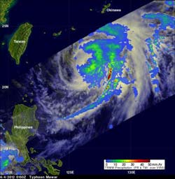
This daylight view of the category three typhoon shows that Mawar had a distinct eye on June 4, 2012, before high clouds began to cover it. A rainfall analysis from TRMM's Microwave Image (TMI) and Precipitation Radar (PR) instruments shows a large area of heavy rainfall in the eastern side. TRMM shows that the northwestern quadrant of the typhoon was drier with very little rainfall occurring in that area. TRMM also shows that a very intense line of heavy rainfall was being fed into the southeastern side of the typhoon. The area of moderate to heavy rainfall appears in red, where rain is falling at over 2 inches/50 mm per hour. Light to moderate rainfall was falling at a rate between .78 inches and 1.57 inches per hour (20 to 40 mm). Credit: NASA/TRMM/SSAI, Hal Pierce<br>
On June 1, Mawar (known as Ambo in the Philippines) had maximum sustained winds near 45 knots and it was about 245 miles east-northeast of Manila, Philippines. On that day, as Mawar continued north, some warnings were posted for the Philippines: Public storm warning signal #1 was up in the Luzon provinces of Catanduanes, Camarines Sur, Camarines Norte, Polillo Island, Aurora, Isabela and Cagayan.
On June 2, more warnings were posted in the Philippines. They include: Public storm warning signal #1 in the Luzon provinces of Isabela and Cagayan including Babuyan Island; and Public storm warning signal #2 was in effect in the Luzon areas of Batanes Group of Islands and Calayan Island.
According to Sunstar news, Manila, the National Disaster Risk Reduction and Management Council (NDRRMC) said that 9 people were injured in Natonin, Mt. Province after their car fell into a ravine. Two others were injured from a landslide. Elsewhere, several people were reported missing.
By June 2, Mawar was already departing the Philippines and was 500 miles south-southwest of Kadena Air Base, Okinawa as its maximum sustained winds reached 80 knots (92 mph/148.2 kph) and it was classified a typhoon. Mawar intensified to typhoon strength when it was about 160.9 km (~100 miles) from Luzon. Flooding from Mawar caused at least three deaths in the Philippines even though the typhoon didn't make landfall.
It later grew in strength to 95 knots (109.3 mph/180 kph), and maintained strength as it headed northeast, until 2100 UTC on June 3, when it was being battered by wind shear. At that time, maximum sustained winds dropped back to 80 knots (92 mph/148.2 kph).
By June 4, 2012 at 1500 UTC (10 a.m. EDT) wind shear had relaxed from battering Mawar and its maximum sustained winds increased back up to 90 knots (103.6 mph/166.7 kph). Tropical-storm-force winds extended out from the center as far as 155 miles (249.4 km), making the storm over 300 miles (499 km) in diameter. The typhoon-force winds, however, we confined to 35 miles (56.3 km) out from the center (about 70 miles in diameter). It was near 23.3 North and 127.4 East, about 185 miles south of Kadena Air Base, Okinawa Mawar continued moving north-northeast near 10 knots (11.5 mph/18.5 kph) and it was generating very rough seas, with wave heights reaching 34 feet (10.3 meters)!
A daylight view from NASA's Tropical Rainfall Measuring Mission (TRMM) satellite showed Mawar had a distinct eye on June 4, 2012 before high clouds began to cover it. A rainfall analysis from TRMM's Microwave Image (TMI) and Precipitation Radar (PR) instruments showed a large area of heavy rainfall in the eastern side. TRMM shows that the northwestern quadrant of the typhoon was drier with very little rainfall occurring in that area. TRMM also showed that a very intense line of heavy rainfall was being fed into the southeastern side of the typhoon.
Satellite imagery also showed that convection (rising air that forms the thunderstorms that make up the storm) and thunderstorms are disorganized. In addition, wind shear appears to be returning and the storm appears to be elongating. Atmospheric conditions are now becoming increasingly hostile and the storm will continue to weaken. Forecasters expect Mawar will become an extra-tropical storm south of Japan by mid-week.
Images and storm history: http://www.nasa.gov/mission_pages/hurricanes/archives/2012/h2012_Mawar.html
Media Contact
More Information:
http://www.nasa.govAll latest news from the category: Earth Sciences
Earth Sciences (also referred to as Geosciences), which deals with basic issues surrounding our planet, plays a vital role in the area of energy and raw materials supply.
Earth Sciences comprises subjects such as geology, geography, geological informatics, paleontology, mineralogy, petrography, crystallography, geophysics, geodesy, glaciology, cartography, photogrammetry, meteorology and seismology, early-warning systems, earthquake research and polar research.


Newest articles

Silicon Carbide Innovation Alliance to drive industrial-scale semiconductor work
Known for its ability to withstand extreme environments and high voltages, silicon carbide (SiC) is a semiconducting material made up of silicon and carbon atoms arranged into crystals that is…

New SPECT/CT technique shows impressive biomarker identification
…offers increased access for prostate cancer patients. A novel SPECT/CT acquisition method can accurately detect radiopharmaceutical biodistribution in a convenient manner for prostate cancer patients, opening the door for more…

How 3D printers can give robots a soft touch
Soft skin coverings and touch sensors have emerged as a promising feature for robots that are both safer and more intuitive for human interaction, but they are expensive and difficult…

