NASA takes a double-look at Tropical Cyclone Blanche
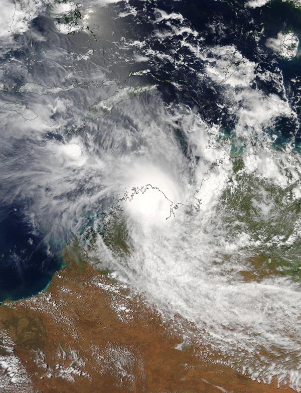
NASA's Aqua satellite captured this visible image of Tropical Cyclone Blanche over northern Australia on Mar. 6 at 05:15 UTC (12:15 a.m. EST). Credits: NASA Goddard MODIS Rapid Response Team
Top End is the northernmost geographical region of Australia's Northern Territory.
The Atmospheric Infrared Sounder or AIRS instrument aboard NASA's Aqua satellite looked at Tropical Cyclone Blanche in infrared light while the Moderate Resolution Imaging Spectroradiometer or MODIS instrument aboard the satellite captured a visible image of the storm. Blanche is located over Australia's Top End.
The AIRS image was taken on Mar. 6 at 05:11 UTC (12:11 a.m. EST) and showed some cloud top temperatures of thunderstorms within Blanche were as cold as minus 63 degrees Fahrenheit (minus 53 degrees Celsius).
Those powerful storms surrounded Blanche's low-level center of circulation. NASA research has shown the storms with cloud tops that cold have the potential to generate heavy rainfall.
Four minutes after AIRS analyzed the storm the MODIS instrument provided a visible picture of Tropical Cyclone Blanche at 05:15 UTC (12:15 a.m. EST). The MODIS image showed that most of Blanche had already moved over land and its northeastern quadrant stretched into the Joseph Bonaparte Gulf.
On March 6 at 1500 UTC (10 a.m. EST), Tropical Cyclone Blanche made landfall on the Kimberley Coast and is dissipating. It was located about 182 nautical miles west-southwest of Darwin, Australia. It was centered near 16.0 degrees south latitude and 127.2 degrees east longitude.
The Joint Typhoon Warning Center's final warning at that time noted that Blanche had maximum sustained winds near 34.5 mph (30 knots/55.5 kph) and was a depression. The storm was moving to the south-southwest at 12.6 mph (11 knots/20.3 kph) and further inland in Top End.
The Australian Bureau of Meteorology noted on March 6 (EDT) to “Expect scattered showers and storms to continue over western Top End with falls of 30 to 80 mm. Heavier rainfall may extend to the Gregory District on Tuesday. Some roads may remain impassable for some time until conditions improve.”
###
See http://www.
Media Contact
All latest news from the category: Earth Sciences
Earth Sciences (also referred to as Geosciences), which deals with basic issues surrounding our planet, plays a vital role in the area of energy and raw materials supply.
Earth Sciences comprises subjects such as geology, geography, geological informatics, paleontology, mineralogy, petrography, crystallography, geophysics, geodesy, glaciology, cartography, photogrammetry, meteorology and seismology, early-warning systems, earthquake research and polar research.


Newest articles

“Nanostitches” enable lighter and tougher composite materials
In research that may lead to next-generation airplanes and spacecraft, MIT engineers used carbon nanotubes to prevent cracking in multilayered composites. To save on fuel and reduce aircraft emissions, engineers…

Trash to treasure
Researchers turn metal waste into catalyst for hydrogen. Scientists have found a way to transform metal waste into a highly efficient catalyst to make hydrogen from water, a discovery that…

Real-time detection of infectious disease viruses
… by searching for molecular fingerprinting. A research team consisting of Professor Kyoung-Duck Park and Taeyoung Moon and Huitae Joo, PhD candidates, from the Department of Physics at Pohang University…

