NASA sees wind shear affecting Tropical Storm Gordon
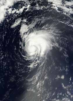
Terra passed over Gordon on Aug. 16, 2012, at 10:25 a.m. EDT (1425 UTC) the Moderate Resolution Imaging Spectroradiometer (MODIS) instrument captured a visible image of the storm. The image showed that the bulk of Gordon's clouds were pushed to the north and northeast as a result of southwesterly wind shear.<br><br>Credit: NASA Goddard MODIS Rapid Response Team<br>
When Terra passed over Gordon on August 16, 2012 at 10:25 a.m. EDT (1425 UTC) the Moderate Resolution Imaging Spectroradiometer (MODIS) instrument captured a visible image of the storm. The image showed that the bulk of Gordon's clouds were pushed to the north and northeast as a result of southwesterly wind shear.
The MODIS image showed what appeared to be a higher, rounded area of thunderstorms surrounding the center, where the most powerful storms were located. Outer bands of thunderstorms wrapping from the north to the east also contained higher, strong thunderstorms. The wind shear continued on August 17 and Gordon's clouds became less symmetric.
On Friday, August 17, at 5 a.m. EDT (0900 UTC) Gordon's maximum sustained winds were near 65 mph (100 kmh) with higher gusts. The National Hurricane Center (NHC) noted that Gordon could still become a hurricane briefly over the weekend of August 18-19. Gordon is a small storm with tropical storm-force winds extending 60 miles (95 km) from the center, and mostly to the north-northeast.
Gordon was centered about 1,195 miles (1925 km) west of the Azores near latitude 34.6 north and longitude 48.1 west. Gordon is moving toward the east near 18 mph (30 kmh) and it is expected to continue in that general direction. A large trough (elongated area) of low pressure over the northeastern Atlantic Ocean will steer Gordon a little to the south and east for the next couple of days.
Although Gordon is expected to move over somewhat cooler waters, computer models used by the National Hurricane Center still indicate that Gordon may become a hurricane, if just for a short time over the next couple of days and then transition into an extra-tropical storm before reaching the Azores. The NHC noted that Gordon should be approaching the Azores late Sunday, August 19.
Meanwhile, in the far eastern Atlantic, the low pressure area dubbed System 94L has now developed. It is located near 11.3 North latitude and 17.9 West longitude, just west of the African coast. System 94L is producing an area of disorganized showers and thunderstorms. The NHC gives System 94L a 10 percent chance of developing into a tropical depression over the weekend.
Media Contact
More Information:
http://www.nasa.govAll latest news from the category: Earth Sciences
Earth Sciences (also referred to as Geosciences), which deals with basic issues surrounding our planet, plays a vital role in the area of energy and raw materials supply.
Earth Sciences comprises subjects such as geology, geography, geological informatics, paleontology, mineralogy, petrography, crystallography, geophysics, geodesy, glaciology, cartography, photogrammetry, meteorology and seismology, early-warning systems, earthquake research and polar research.


Newest articles

Properties of new materials for microchips
… can now be measured well. Reseachers of Delft University of Technology demonstrated measuring performance properties of ultrathin silicon membranes. Making ever smaller and more powerful chips requires new ultrathin…

Floating solar’s potential
… to support sustainable development by addressing climate, water, and energy goals holistically. A new study published this week in Nature Energy raises the potential for floating solar photovoltaics (FPV)…

Skyrmions move at record speeds
… a step towards the computing of the future. An international research team led by scientists from the CNRS1 has discovered that the magnetic nanobubbles2 known as skyrmions can be…

