NASA Sees Typhoon Trami Passing Taiwan for China Landfall
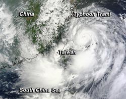
At 10:45 p.m. EDT on Aug. 20, NASA's Terra satellite passed over Typhoon Trami on its approach to China and Taiwan. Image Credit: NASA Goddard MODIS Rapid Response Team<br>
On Aug. 21 at 02:45 UTC/10:45 p.m. EDT on Aug. 20, NASA's Terra satellite passed over the Northwestern Pacific Ocean and the Moderate Resolution Imaging Spectroradiometer or MODIS instrument that flies aboard it, captured a visible image of Trami.
The MODIS image showed a tight circulation center with bands of thunderstorms have wrapped more tightly into the center of circulation from the north to east to south of the center. The band of thunderstorms south of the center covers the largest area, and appears almost the same size as the center of Trami's circulation center in the MODIS image.
By 1200 UTC/8 a.m. EDT on Aug. 21, Trami's center had passed Taiwan and was in the Taiwan Strait. The Taiwan Strait is a body of water between the western side of the island nation of Taiwan and eastern China.
At 1500 UTC, Trami's center was near 26.0 north latitude and 120.5 east longitude, about 45 nautical miles/51.7 miles/83.3 km north-northwestward of Taipei, Taiwan. Trami's maximum sustained winds are near 70 knots/80 mph/`19.6 kph. Tropical-storm-force winds extend out 100 nautical miles/115 miles/185 km from the center, and northern Taiwan was experiencing them at 1500 UTC. Trami is moving to the west at 15 knots/17.2 mph/27.8 kph and is generating 28-foot/8.5 meter-high seas causing rough surf in northern Taiwan and eastern China.
According to the China Meteorological Agency, Trami is expected to make landfall today, Aug. 21 (or early morning Aug. 22 local time) near Fuzhou, China. An Orange Typhoon Warning is in effect, and eastern Guangdong, most of Fujian, central and southern Zhejiang and Taiwan are expected to receive heavy rainfall as Typhoon Trami closes in for landfall.
Unlabeled image
Text credit: Rob Gutro
NASA's Goddard Space Flight Center
Media Contact
All latest news from the category: Earth Sciences
Earth Sciences (also referred to as Geosciences), which deals with basic issues surrounding our planet, plays a vital role in the area of energy and raw materials supply.
Earth Sciences comprises subjects such as geology, geography, geological informatics, paleontology, mineralogy, petrography, crystallography, geophysics, geodesy, glaciology, cartography, photogrammetry, meteorology and seismology, early-warning systems, earthquake research and polar research.


Newest articles

Silicon Carbide Innovation Alliance to drive industrial-scale semiconductor work
Known for its ability to withstand extreme environments and high voltages, silicon carbide (SiC) is a semiconducting material made up of silicon and carbon atoms arranged into crystals that is…

New SPECT/CT technique shows impressive biomarker identification
…offers increased access for prostate cancer patients. A novel SPECT/CT acquisition method can accurately detect radiopharmaceutical biodistribution in a convenient manner for prostate cancer patients, opening the door for more…

How 3D printers can give robots a soft touch
Soft skin coverings and touch sensors have emerged as a promising feature for robots that are both safer and more intuitive for human interaction, but they are expensive and difficult…

