NASA sees Typhoon Soulik's eye closed for 'renovations'
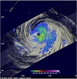
The TRMM satellite flew over Soulik on July 10 at 14:06 UTC and saw a well-defined eye and multiple intense (red) and moderate and weak (green, blue) that wrapped tightly around the eye.<br><br>Credit: NASA/SSAI, Hal Pierce<br>
When NASA's Aqua satellite passed over Typhoon Soulik on July 11 an instrument aboard noticed clouds filled the eye and additional data showed the eyewall was being replaced.
On July 11 at 04:20 UTC (12:20 a.m. EDT), NASA's Aqua satellite flew over Typhoon Soulik in the western Pacific Ocean. The Moderate Resolution Imaging Spectroradiometer (MODIS) instrument saw that Soulik's eye had become cloud-filled and the storm's maximum sustained winds had dropped since the previous day. However, satellite data indicates the eye is reforming.
The Joint Typhoon Warning Center forecasters use multi-spectral satellite imagery when assessing a tropical cyclone and noted that imagery showed multiple bands of thunderstorms wrapping around Soulik's center, and the ragged cloud-filled eye was still 20 nautical miles (23 miles/37 km) in diameter. Microwave satellite imagery confirmed the reforming eye, and showed that those strong bands of thunderstorms were wrapping around the southern side of the storm.
Eyewall Replacement
Whenever a super typhoon or major hurricane has sustained winds over 100 knots (115 mph/185 kph), eyewall replacement occurs naturally. That happens because the eyewall is small, or it contracts and some of the outer bands of thunderstorms can strengthen and form a ring or outer eyewall. That outer ring moves inward and takes energy from the inner eyewall. During the replacement, a typhoon or hurricane weakens, as Soulik has done. Eventually the inner eyewall is replaced by the outer eyewall. Once the replacement is completed, the storm may re-intensify.
Soulik Reached Super Typhoon Status
It was just yesterday, July 10 at 0000 UTC (July 9 at 8 p.m. EDT) that Typhoon Soulik became the first super typhoon of the year when the Joint Typhoon Warning Center estimated that it's sustained winds had increased to 125 knots (~144 mph), which is equivalent to a Category 4 hurricane on the U.S. Saffir-Simpson scale.
NASA's TRMM Satellite
NASA and the Japanese Space Agency's Tropical Rainfall Measuring Mission or TRMM satellite flew over Soulik on July 10 at 14:06 UTC (10:06 a.m. EDT) and measured rainfall rates occurring within the storm. TRMM data showed that Soulik had all of the features of a powerful, mature tropical cyclone, including a well-defined eye and multiple intense rain bands (red, green and blue areas indicating intense, moderate and weak rain intensity, respectively) that wrap tightly around the eye, which reflect the storm's strong cyclonic circulation.
Soulik's Status
On July 11 at 0900 UTC (5 a.m. EDT), Typhoon Soulik's maximum sustained winds dropped to near 90 knots (103.6 mph/166.7 kph). On July 10 at 1500 UTC (11 a.m. EDT) Soulik's maximum sustained winds were blowing at 120 knots (138 mph/222 kph) and NASA's Terra satellite captured a clear image of the storm's eye.
Soulik is still moving in a westerly direction through the northwestern Pacific Ocean and at a speed of 12 knots. Typhoon Soulik was located near latitude 22.4 north and longitude 129.1 east, about 273 nautical miles (314 miles/505 km) south-southeast of Kadena Air Base. Soulik's powerful winds were stirring up maximum wave heights near 38 feet (11.5 meters).
According to the Joint Typhoon Warning Center, Typhoon Soulik is forecast to move just south of Japan's Ishigaki-jima Island early on July 12, and brush the northern end of Taiwan later in the day as it heads to China for landfall on July 13.
Media Contact
More Information:
http://www.nasa.govAll latest news from the category: Earth Sciences
Earth Sciences (also referred to as Geosciences), which deals with basic issues surrounding our planet, plays a vital role in the area of energy and raw materials supply.
Earth Sciences comprises subjects such as geology, geography, geological informatics, paleontology, mineralogy, petrography, crystallography, geophysics, geodesy, glaciology, cartography, photogrammetry, meteorology and seismology, early-warning systems, earthquake research and polar research.


Newest articles

High-energy-density aqueous battery based on halogen multi-electron transfer
Traditional non-aqueous lithium-ion batteries have a high energy density, but their safety is compromised due to the flammable organic electrolytes they utilize. Aqueous batteries use water as the solvent for…

First-ever combined heart pump and pig kidney transplant
…gives new hope to patient with terminal illness. Surgeons at NYU Langone Health performed the first-ever combined mechanical heart pump and gene-edited pig kidney transplant surgery in a 54-year-old woman…

Biophysics: Testing how well biomarkers work
LMU researchers have developed a method to determine how reliably target proteins can be labeled using super-resolution fluorescence microscopy. Modern microscopy techniques make it possible to examine the inner workings…

