NASA sees Typhoon Nangka knocking on Japan's door
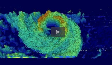
NASA/JAXA's Global Precipitation Measurement (GPM) core observatory satellite passed above Typhoon Nangka on July 15 at 12:21 p.m. EDT and saw the highest thunderstorm tops in the western eye wall were about 12 km (7.4 miles) high. Credit: NASA/JAXA/SSAI, Hal Pierce
NASA/JAXA's Global Precipitation Measurement (GPM) core observatory satellite passed above Typhoon Nangka on July 15, 2015 at 1621 UTC (12:21 p.m. EDT) as the weakening typhoon approached the Japanese island of Shikoku.
GPM's Dual-Frequency Precipitation Radar (DPR) instrument revealed that the highest thunderstorm tops in Nangka's western eye wall were then reaching heights of about 12 km (7.4 miles).
On July 16 at 2:05 UTC (July 15 at 10:05 p.m. EDT) the MODIS instrument aboard NASA's Terra satellite captured a visible image of Typhoon Nangka affecting southeastern Japan.
The MODIS image showed that Nangka maintained its eye and that eye was surrounded by thick, spiraling bands of thunderstorms out to about 150 nautical miles from the center making the storm over 300 nautical miles wide.
By 1500 UTC (11 a.m. EDT), Typhoon Nangka had moved to just 142 nautical miles southeast of Iwakuni, Japan, centered near 32.9 North and 134.4 East. Nangka's maximum sustained winds were down to 65 knots (75 mph/120 kph) making it a minimal category 1 typhoon. Nangka was moving to the north at 10 knots (11.5 mph/18.5 kph).
Nangka is moving north and is approaching a landfall in mainland Japan. The storm is expected to move north over Japan and rapidly weaken as it veers northeast.
Media Contact
All latest news from the category: Earth Sciences
Earth Sciences (also referred to as Geosciences), which deals with basic issues surrounding our planet, plays a vital role in the area of energy and raw materials supply.
Earth Sciences comprises subjects such as geology, geography, geological informatics, paleontology, mineralogy, petrography, crystallography, geophysics, geodesy, glaciology, cartography, photogrammetry, meteorology and seismology, early-warning systems, earthquake research and polar research.


Newest articles

“Nanostitches” enable lighter and tougher composite materials
In research that may lead to next-generation airplanes and spacecraft, MIT engineers used carbon nanotubes to prevent cracking in multilayered composites. To save on fuel and reduce aircraft emissions, engineers…

Trash to treasure
Researchers turn metal waste into catalyst for hydrogen. Scientists have found a way to transform metal waste into a highly efficient catalyst to make hydrogen from water, a discovery that…

Real-time detection of infectious disease viruses
… by searching for molecular fingerprinting. A research team consisting of Professor Kyoung-Duck Park and Taeyoung Moon and Huitae Joo, PhD candidates, from the Department of Physics at Pohang University…

