NASA Sees Typhoon Matmo Making Second Landfall in China
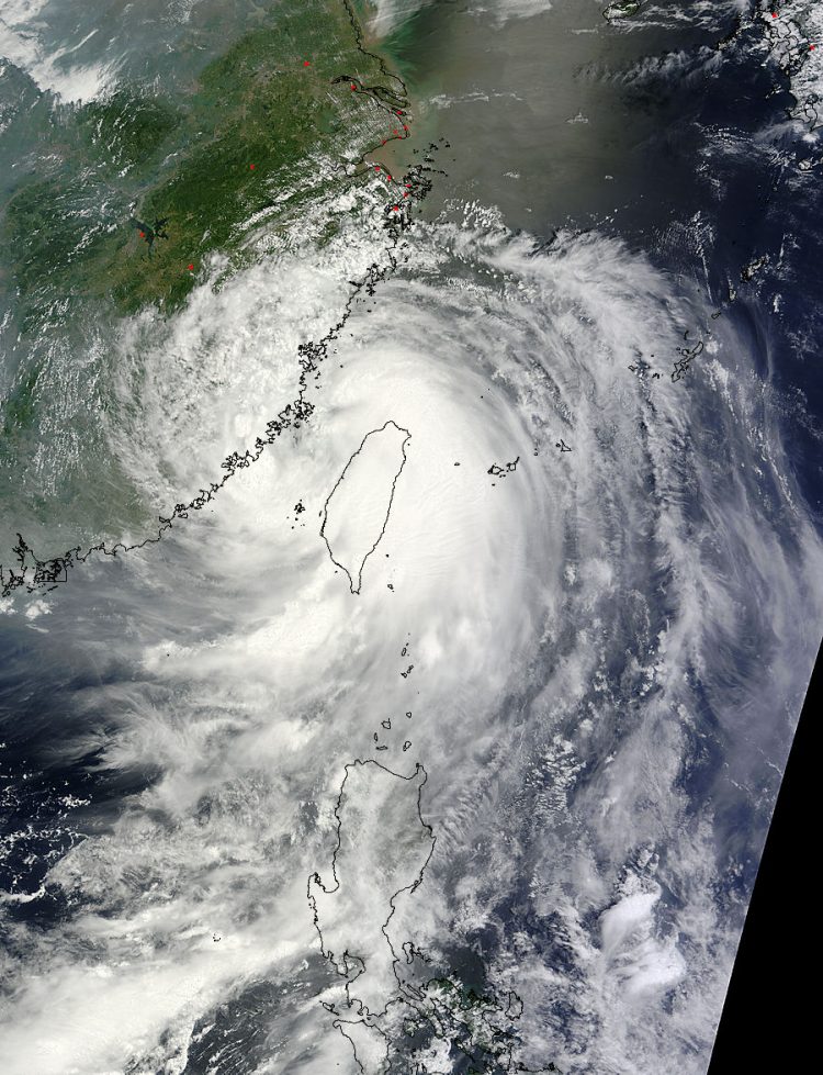
NASA's Terra satellite caught this visible image of Typhoon Matmo moving through the Taiwan Strait on July 23 at 02:45 UTC, headed for a landfall in southeastern China. Image Credit: NASA Goddard MODIS Rapid Response Team
On July 23 at 02:45 UTC (July 22 at 10:45 p.m. EDT), the Moderate Resolution Imaging Spectroradiometer or MODIS instrument aboard NASA's Terra satellite captured a picture of Typhoon Matmo after its center crossed the northern part of the island nation of Taiwan and entered the Taiwan Strait.
The Taiwan Strait is the body of water between western Taiwan and southeastern China. The MODIS image showed a cloud-covered center of circulation, but a cloud extent that covered Taiwan
Matmo made land fall along China’s southeastern coastal province of Fujian early on July 23. Matmo made landfall with maximum sustained winds near 74 knots (137 kph/85 mph) making it a category one typhoon on the Saffir-Simpson hurricane scale.
By 1500 UTC (11 a.m. EDT) Matmo's center had moved inland over southeastern China. It was centered near 26.4 north latitude and 118.9 east longitude, about 142 nautical miles west-northwest of Taipei, Taiwan.
Matmo's maximum sustained winds dropped quickly to 50 knots (57.5 mph/92.6 kph) and the Joint Typhoon Warning Center (JTWC) forecast calls for rapid weakening because of friction caused by moving over land, and an approaching mid-latitude trough (elongated area of low pressure). Matmo was moving to the northwest at 10 knots (11.5 mph/17.5 kph).
JTWC noted that complete dissipation of the system is expected over land, approximately 150 nautical miles west of Shanghai in the next day as it is absorbed in the mid-latitude boundary currently located north of the system.
Text credit: Rob Gutro
NASA's Goddard Space Flight Center
Media Contact
All latest news from the category: Earth Sciences
Earth Sciences (also referred to as Geosciences), which deals with basic issues surrounding our planet, plays a vital role in the area of energy and raw materials supply.
Earth Sciences comprises subjects such as geology, geography, geological informatics, paleontology, mineralogy, petrography, crystallography, geophysics, geodesy, glaciology, cartography, photogrammetry, meteorology and seismology, early-warning systems, earthquake research and polar research.


Newest articles

High-energy-density aqueous battery based on halogen multi-electron transfer
Traditional non-aqueous lithium-ion batteries have a high energy density, but their safety is compromised due to the flammable organic electrolytes they utilize. Aqueous batteries use water as the solvent for…

First-ever combined heart pump and pig kidney transplant
…gives new hope to patient with terminal illness. Surgeons at NYU Langone Health performed the first-ever combined mechanical heart pump and gene-edited pig kidney transplant surgery in a 54-year-old woman…

Biophysics: Testing how well biomarkers work
LMU researchers have developed a method to determine how reliably target proteins can be labeled using super-resolution fluorescence microscopy. Modern microscopy techniques make it possible to examine the inner workings…

