NASA sees troublesome remnants of Cyclone Oswald still causing problems
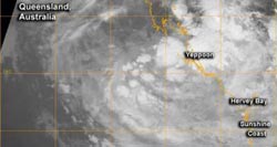
NASA's Aqua satellite passed over Oswald's remnants on Jan. 25 at 1458 UTC (9:58 a.m. ES/U.S.) as it hugged the southeastern coast of Queensland, dumping heavy rainfall.<br><br>Credit: NRL/NASA<br>
Oswald has dropped a lot of rainfall throughout Queensland. An earlier rainfall analysis using NASA's TRMM satellite data showed Oswald and its remnants had dropped over 600 mm (~23.6 inches) of rain in areas of the Cape York Peninsula near the Gulf of Carpentaria. Higher rainfall totals have been recorded over the southern Capricornia district.
On Saturday, Jan. 26 at 4 a.m. Queensland local time (or 3 p.m. EST/U.S. on Jan. 25) ex-Tropical Cyclone Oswald was located over land in Queensland, Australia, about 55 nautical miles (63 miles/ 102 km) northeast of Emerald and 85 nautical miles (97.8 miles/ 157.4 km) west northwest of Rockhampton.
Oswald and a trough of low pressure are bringing heavy rainfall to eastern Queensland. The trough, an elongated area of low pressure, stretches from the southern Gulf of Carpentaria to ex-Tropical Cyclone Oswald and over to the southern Capricornia coast. Ex-Tropical Cyclone Oswald and the trough are expected to continue moving southwards over the next few days.
NASA's Aqua satellite passed over Oswald's remnants on Jan. 25 at 1458 UTC (9:58 a.m. ES/U.S.) and the Moderate Resolution Imaging Spectroradiometer (MODIS) instrument aboard captured an infrared image of the storm. At the time, Oswald's maximum sustained winds were near 25 knots (28.7 mph/46.3 kph), and minimum central pressure was near 995 millibars. At the time Aqua passed over some of the strongest storms and heaviest rainfall appeared west and east of Yeppoon and over Hervey Bay.
As Oswald's remnants continue to hug the eastern Queensland coast, residents can expect gusty winds, rough seas, heavy rainfall, and possible flash flooding.
There are gale warnings in effect over many areas, including: St. Lawrence to Burnett Head; Burnett Heads to Double Island Point, including Hervey Bay; Double Island Point to Point Danger, including Moreton Bay; and Bowen to St. Lawrence.
According to the Australian Bureau of Meteorology (ABM), on Jan. 25 at 2 p.m. EST, the heaviest rainfall was occurring over the southern Capricornia district. ABM noted that rainfall in excess of 27.5 inches (700 mm) in less than 2 days, leading to rapid river and stream rises in the area.
For updates on Oswald's remnants, visit: http://www.bom.gov.au/australia/warnings/index.shtml
Media Contact
All latest news from the category: Earth Sciences
Earth Sciences (also referred to as Geosciences), which deals with basic issues surrounding our planet, plays a vital role in the area of energy and raw materials supply.
Earth Sciences comprises subjects such as geology, geography, geological informatics, paleontology, mineralogy, petrography, crystallography, geophysics, geodesy, glaciology, cartography, photogrammetry, meteorology and seismology, early-warning systems, earthquake research and polar research.


Newest articles

Properties of new materials for microchips
… can now be measured well. Reseachers of Delft University of Technology demonstrated measuring performance properties of ultrathin silicon membranes. Making ever smaller and more powerful chips requires new ultrathin…

Floating solar’s potential
… to support sustainable development by addressing climate, water, and energy goals holistically. A new study published this week in Nature Energy raises the potential for floating solar photovoltaics (FPV)…

Skyrmions move at record speeds
… a step towards the computing of the future. An international research team led by scientists from the CNRS1 has discovered that the magnetic nanobubbles2 known as skyrmions can be…

