NASA Sees Tropical Storm Tembin Make Landfall in South Korea
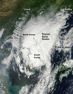
NASA's Aqua satellite's MODIS instrument captured this visible, true-color image of Tropical Storm Tembin at the time of landfall in southwestern South Korea. The image was captured at 04:45 UTC (12:45 a.m. EDT) on Aug. 30.<br>Credit: NASA Goddard /MODIS Rapid Response Team <br>
Tembin moved through the Myeongnyang Strait and made landfall on Aug. 30, 2012 at 0000 UTC (Aug. 29 at 8 p.m. EDT) in the southwestern tip of South Korea.
NASA's Aqua satellite's Moderate Resolution Imaging Spectroradiometer (MODIS) instrument captured a visible, true-color image of Tropical Storm Tembin around the time of landfall in southwestern South Korea. The image was captured at 04:45 UTC (12:45 a.m. EDT) on Aug. 30, and showed an elongated storm stretching from southwestern South Korea, over North Korea and into the Sea of Japan. Southwesterly wind shear has also taken its toll on Tembin as the storm has become elongated. When a storm is no longer circular, it loses its energy.
Satellite imagery also revealed that central convection (rising air that forms thunderstorms that make up Tembin) have been decaying rapidly.
On Aug. 30 at 0300 UTC (Aug. 29 at 11 p.m. EDT) Tropical Storm Tembin's maximum sustained winds were near 35 knots (40 mph/65 kmh). It was located about 85 nautical miles (97.8 miles/157.4 km) south of Kunsan Air Base, South Korea, near 35.5 North and 127.2 East. Tembin is moving to the north-northeast at 23 knots (26.4 mph/42.6 kmh) and forecasters at the Joint Typhoon Warning Center expect the storm to continue accelerating and drag across the rugged Taebaek Mountain Range, further weakening it.
Tembin is then is expected to briefly enter the Sea of Japan as an extra-tropical low pressure area and dissipate thereafter.
Text Credit: Rob Gutro
NASA Goddard Space Flight Center, Greenbelt, Md.
Media Contact
All latest news from the category: Earth Sciences
Earth Sciences (also referred to as Geosciences), which deals with basic issues surrounding our planet, plays a vital role in the area of energy and raw materials supply.
Earth Sciences comprises subjects such as geology, geography, geological informatics, paleontology, mineralogy, petrography, crystallography, geophysics, geodesy, glaciology, cartography, photogrammetry, meteorology and seismology, early-warning systems, earthquake research and polar research.


Newest articles

Bringing bio-inspired robots to life
Nebraska researcher Eric Markvicka gets NSF CAREER Award to pursue manufacture of novel materials for soft robotics and stretchable electronics. Engineers are increasingly eager to develop robots that mimic the…

Bella moths use poison to attract mates
Scientists are closer to finding out how. Pyrrolizidine alkaloids are as bitter and toxic as they are hard to pronounce. They’re produced by several different types of plants and are…

AI tool creates ‘synthetic’ images of cells
…for enhanced microscopy analysis. Observing individual cells through microscopes can reveal a range of important cell biological phenomena that frequently play a role in human diseases, but the process of…

