NASA sees Tropical Storm Rosa being born and powering up quickly
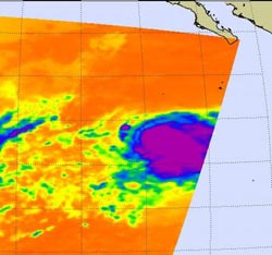
The AIRS instrument aboard NASA's Aqua satellite captured this image of Tropical Depression 17 on October 30 at 5:41 a.m. EDT before it intensified into Tropical Storm Rosa. The strongest storms with coldest cloud top temperatures appear in purple. The purple indicates temperatures as cold as -63F (-52C).<br><br>Credit: Credit: NASA JPL, Ed Olsen<br>
When NASA's Aqua satellite flew over Tropical Depression 17E at 5:41 a.m. EDT (0951 UTC) on Tuesday, October 30, the Atmospheric Infrared Sounder (AIRS) instrument took an infrared picture of the storm.
The AIRS data showed a large, circular area of very strong convection (rising air that forms thunderstorms that make up a tropical cyclone) around the storm's center. Scientists identify the convection as strong, because the air pushes cloud tops of those thunderstorms to the top of the troposphere where temperatures are as cold as or colder than -63 Fahrenheit (-52 Celsius).
The AIRS data showed that those clouds were near that temperature, indicating they were high in the atmosphere, and when they're that high, they're powerful, and are typically indicative of heavy rainfall.
At 8 a.m. EDT (1500 UTC) the center of Tropical Storm Rosa was located near latitude 14.5 north and longitude 116.5 west. Rosa is moving toward the west-northwest near 7 mph (11 kph) away from the mainland. Rosa is expected to continue in that direction and turn more to the west in the next couple of days. Rosa's estimated minimum central pressure is 1004 millibars.
Rosa's maximum sustained winds were near 40 mph (65 kph) and the National Hurricane Center expects some strengthening later today and October 31 before weakening on November 1.
Media Contact
More Information:
http://www.nasa.govAll latest news from the category: Earth Sciences
Earth Sciences (also referred to as Geosciences), which deals with basic issues surrounding our planet, plays a vital role in the area of energy and raw materials supply.
Earth Sciences comprises subjects such as geology, geography, geological informatics, paleontology, mineralogy, petrography, crystallography, geophysics, geodesy, glaciology, cartography, photogrammetry, meteorology and seismology, early-warning systems, earthquake research and polar research.


Newest articles

High-energy-density aqueous battery based on halogen multi-electron transfer
Traditional non-aqueous lithium-ion batteries have a high energy density, but their safety is compromised due to the flammable organic electrolytes they utilize. Aqueous batteries use water as the solvent for…

First-ever combined heart pump and pig kidney transplant
…gives new hope to patient with terminal illness. Surgeons at NYU Langone Health performed the first-ever combined mechanical heart pump and gene-edited pig kidney transplant surgery in a 54-year-old woman…

Biophysics: Testing how well biomarkers work
LMU researchers have developed a method to determine how reliably target proteins can be labeled using super-resolution fluorescence microscopy. Modern microscopy techniques make it possible to examine the inner workings…

