NASA sees Tropical Storm Omais weakening near Japan
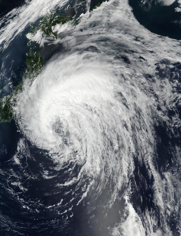
This true-color image from the NASA-NOAA Suomi NPP satellite on Aug. 7, 2016, at 11:05 p.m. EDT (Aug. 8 at 3:05 a.m. UTC) shows Tropical Storm Omais east of central Japan. Credit: NOAA/NASA
On Aug. 7 at 11:05 p.m. EDT (Aug.8 at 3:05 a.m. UTC) the Visible Infrared Imaging Radiometer Suite (VIIRS) instrument aboard NASA-NOAA's Suomi NPP satellite captured a visible light image of Omais in the northwestern Pacific Ocean. The VIIRS image showed that the bulk of Omais' thunderstorms were north and west of the center of circulation. Omais' center was visible in the image, and the southeastern quadrant seems to be devoid of thunderstorm development.
A false-colored infrared image from the AIRS instrument aboard NASA's Aqua satellite showed Tropical Storm Omais' coldest cloud tops and strongest thunderstorms over northern Japan on Aug. 8. The image also showed that the storm is elongating, which is a sign of weakening. The image was created at NASA's Jet Propulsion Laboratory in Pasadena, California.
On Aug. 8 at 11 a.m. EDT (3 p.m. UTC) Omais' maximum sustained winds were near 46 mph (40 knots/74 kph). It was centered near 36.2 degrees north latitude and 144.7 degrees east longitude, about 230 nautical miles east of Yokosuka, Japan. Omais was moving to the north at 11.5 mph (10 knots/18.5 kph).
The Japan Meteorological Agency has posted warnings and watches for northern Japan. To see the warning areas, visit: http://www.
The Joint Typhoon Warning Center expects Omais to curve to the northeast while remaining to the east of the Kuril Islands and transition into an extra-tropical storm over the next couple of days.
Media Contact
All latest news from the category: Earth Sciences
Earth Sciences (also referred to as Geosciences), which deals with basic issues surrounding our planet, plays a vital role in the area of energy and raw materials supply.
Earth Sciences comprises subjects such as geology, geography, geological informatics, paleontology, mineralogy, petrography, crystallography, geophysics, geodesy, glaciology, cartography, photogrammetry, meteorology and seismology, early-warning systems, earthquake research and polar research.


Newest articles

Superradiant atoms could push the boundaries of how precisely time can be measured
Superradiant atoms can help us measure time more precisely than ever. In a new study, researchers from the University of Copenhagen present a new method for measuring the time interval,…

Ion thermoelectric conversion devices for near room temperature
The electrode sheet of the thermoelectric device consists of ionic hydrogel, which is sandwiched between the electrodes to form, and the Prussian blue on the electrode undergoes a redox reaction…

Zap Energy achieves 37-million-degree temperatures in a compact device
New publication reports record electron temperatures for a small-scale, sheared-flow-stabilized Z-pinch fusion device. In the nine decades since humans first produced fusion reactions, only a few fusion technologies have demonstrated…

