NASA sees Tropical Storm Haima poised for Vietnam landfall
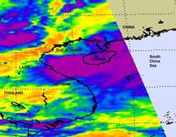
NASA's Aqua satellite passed over Haima on June 23 at 06:23 UTC (2:23 a.m. EDT) when its center was near Hainan Island, China. At that time, most of its heaviest thunderstorms (purple) were over the waters of the South China Sea, dropping rain at 2 inches/50 mm per hour. Credit: NASA/JPL, Ed Olsen<br>
On June 24. 2011 at 0600 UTC (2 a.m. EDT), Tropical Storm Haima's winds were back up to 35 knots (40 mph/65 kmh) making it a minimal tropical storm. Haima is headed west-southwest at 10 knots (11 mph/19 kmh). Its center was near 20.3 North and 107.0 East about 90 nautical miles east-southeast of Hanoi, Vietnam.
Hanoi, Vietnam is north of where Haima is expected to make landfall and has been experiencing light rains from the western-most fringe of the tropical storm. On June 24 at 9 a.m. EDT, Hanoi had mostly cloudy skies and light rain with winds from the north at 16 mph. The temperature was 80 Fahrenheit (27 Celsius) and the minimum central pressure was 993 millibars (and dropping).
NASA's Aqua satellite passed over Haima on June 23 at 06:23 UTC (2:23 a.m. EDT) when its center was near Hainan Island, China. At that time, most of its heaviest thunderstorms were over the waters of the South China Sea, dropping rain at 2 inches/50 mm per hour. The Atmospheric Infrared Sounder (AIRS) instrument data showed a small area of strong convection and thunderstorms mostly south of the center of circulation.
Because infrared imagery shows temperature, it revealed that those thunderstorms had cold cloud top temperatures as cold as or colder than -63 Fahrenheit (-52 Celsius). On June 24, a microwave satellite image confirmed that the strongest convection and thunderstorms remained over the south of the center.
The warm waters of the Gulf of Tonkin have helped to reinvigorate Haima. Warm waters over 80F (26.5C) provide energy for a tropical cyclone. The waters in the Gulf of Tonkin are near 89.5F (32C).
The other factor that is critical in the strength of a tropical cyclone is wind shear. Strong wind shear can batter a storm and tear it apart. Current wind shear in the vicinity of Haima is between 15 and 20 knots (17-23 mph/27-37 kmh) and is expected to remain at that level through Haima's landfall in Vietnam tomorrow. That wind shear will help keep Haima from strengthening into a cyclone, although the Joint Typhoon Warning Center noted that it is expected to make landfall as a marginal tropical storm before dissipating over land.
NASA Hurricane Page: www.nasa.gov/hurricane
Media Contact
All latest news from the category: Earth Sciences
Earth Sciences (also referred to as Geosciences), which deals with basic issues surrounding our planet, plays a vital role in the area of energy and raw materials supply.
Earth Sciences comprises subjects such as geology, geography, geological informatics, paleontology, mineralogy, petrography, crystallography, geophysics, geodesy, glaciology, cartography, photogrammetry, meteorology and seismology, early-warning systems, earthquake research and polar research.


Newest articles

Superradiant atoms could push the boundaries of how precisely time can be measured
Superradiant atoms can help us measure time more precisely than ever. In a new study, researchers from the University of Copenhagen present a new method for measuring the time interval,…

Ion thermoelectric conversion devices for near room temperature
The electrode sheet of the thermoelectric device consists of ionic hydrogel, which is sandwiched between the electrodes to form, and the Prussian blue on the electrode undergoes a redox reaction…

Zap Energy achieves 37-million-degree temperatures in a compact device
New publication reports record electron temperatures for a small-scale, sheared-flow-stabilized Z-pinch fusion device. In the nine decades since humans first produced fusion reactions, only a few fusion technologies have demonstrated…

