NASA sees Tropical Storm Daniel move over cooler water
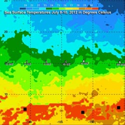
This analysis of sea surface temperatures is from July 8-10, 2012. Daniel's predicted path (shown in white) takes it over water with temperatures of about 24-25 C (~75.2 to 77.0 F). The boundary of 26 C (~79 F ) temperatures are shown in yellow on this analysis. Credit: Credit: NASA/SSAI, Hal Pierce<br>
The TRMM satellite flew above weakening tropical storm Daniel on July 10, 2012 at 0003 UTC. TRMM's Microwave Imager (TMI) and Precipitation Radar (PR) data from that pass showed that only light to moderate rainfall (.0.78 to 1.57 inches/20 to 40 mm/hour) was occurring with the weakening storm.
At NASA's Goddard Space Flight Center in Greenbelt, Md. Hal Pierce of the TRMM team created an analysis that showed averaged Sea Surface Temperatures (SST). The SST data was derived from TRMM Microwave Imager (TMI) data for the period from July 8-10, 2012. Daniel's predicted path takes it over water with temperatures of about 24-25 C (~75.2 to 77.0 F). Water needs to be around 26 C (~79 F ) to fuel a tropical cyclone so Daniel is predicted to gradually weaken to a tropical depression over the next couple days.
At 5 a.m. EDT on July 11, 2012 Tropical Storm Daniel had maximum sustained winds near 40 mph (65 kmh) and was moving to the west near 16 mph (26 kmh). Daniel was about 1,055 miles (1,700 km) east-southeast of Hilo, Hawaii near 15.4 North and 139.7 West. Satellite data indicates that only a small area of deep convection (rising air that form the thunderstorms that make up the tropical cyclone) remains south and southeast of Daniel's center.
When TRMM passed over Daniel on July 11 at 0858 UTC, it observed a few strong thunderstorms near Daniel's center of circulation reaching to heights of over 11km (~6.8 miles). Radar reflectivity values of almost 42 dBZ were being returned to TRMM PR indicating that moderate to heavy rainfall was occurring in that area.
Daniel is crossing over into the central Pacific Ocean today. On Friday the weakening tropical depression is expected to be south-southeast of the Hawaiian Islands.
Media Contact
More Information:
http://www.nasa.govAll latest news from the category: Earth Sciences
Earth Sciences (also referred to as Geosciences), which deals with basic issues surrounding our planet, plays a vital role in the area of energy and raw materials supply.
Earth Sciences comprises subjects such as geology, geography, geological informatics, paleontology, mineralogy, petrography, crystallography, geophysics, geodesy, glaciology, cartography, photogrammetry, meteorology and seismology, early-warning systems, earthquake research and polar research.


Newest articles

Boron deficiency: oilseed rape reacts as with infection and pest infestation
Genetic mechanisms uncovered… Boron deficiency has a devastating effect on oilseed rape and related plants. However, little is known about the underlying genetic mechanisms. A study shows that the response…

Security vulnerability in browser interface
… allows computer access via graphics card. Researchers at Graz University of Technology were successful with three different side-channel attacks on graphics cards via the WebGPU browser interface. The attacks…

A closer look at mechanochemistry
Ferdi Schüth and his team at the Max Planck Institut für Kohlenforschung in Mülheim/Germany have been studying the phenomena of mechanochemistry for several years. But what actually happens at the…

