NASA sees Tropical Storm Chantal develop quickly in Atlantic
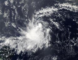
The MODIS instrument aboard NASA's Aqua satellite captured a visible image of Tropical Storm Chantal on July 7 at 12:15 p.m. EDT when it was located off the coast of Brazil.<br><br>Credit: NASA Goddard MODIS Rapid Response<br>
The Moderate Resolution Imaging Spectroradiometer (MODIS) instrument that flies aboard NASA's Aqua satellite captured a visible image of Tropical Storm Chantal on July 7 at 12:15 p.m. EDT when it was located off the coast of Brazil. The highest and strongest thunderstorms (that cast shadows on the surrounding lower storms) were around the center of circulation.
On Monday, July 8, Chantal was nearing land areas and warnings and watches were posted. A Tropical Storm Warning is in effect for Barbado, Dominica, Saint Lucia, Martinique, and Guadeloupe, and a Tropical Storm Watch is in effect for Saint Vincent.
In the warning area by early Tuesday, July 9, the National Hurricane Center or NHC expects tropical storm conditions. Those conditions are expected in the watch area later on July 9. Chantal is expected to bring the Leeward and Windward islands rainfall between 2 and 4 inches, with isolated totals to 6 inches.
At 8 a.m. EDT (1200 UTC) Chantal's maximum sustained winds were near 40 mph (65 kph) and are expected to increase. The center of Tropical Storm Chantal was located near latitude 10.6 north and longitude 50.6 west. The estimated minimum central pressure is 1007 millibars. The NHC reported that Chantal is moving toward the west near 26 mph (43 kph) and a west-northwestward motion at about the same forward speed is expected over the next couple of days.
Chantal developed from an unseasonally strong easterly wave that moved off the African coast on July 3, according to Brian McNoldy, Senior Research Associate at University of Miami's Rosenstiel School of Marine and Atmospheric Science.
After affecting the Lesser Antilles Tuesday, Chantal is expected to move into the eastern Caribbean Sea.
Media Contact
More Information:
http://www.nasa.govAll latest news from the category: Earth Sciences
Earth Sciences (also referred to as Geosciences), which deals with basic issues surrounding our planet, plays a vital role in the area of energy and raw materials supply.
Earth Sciences comprises subjects such as geology, geography, geological informatics, paleontology, mineralogy, petrography, crystallography, geophysics, geodesy, glaciology, cartography, photogrammetry, meteorology and seismology, early-warning systems, earthquake research and polar research.


Newest articles

Superradiant atoms could push the boundaries of how precisely time can be measured
Superradiant atoms can help us measure time more precisely than ever. In a new study, researchers from the University of Copenhagen present a new method for measuring the time interval,…

Ion thermoelectric conversion devices for near room temperature
The electrode sheet of the thermoelectric device consists of ionic hydrogel, which is sandwiched between the electrodes to form, and the Prussian blue on the electrode undergoes a redox reaction…

Zap Energy achieves 37-million-degree temperatures in a compact device
New publication reports record electron temperatures for a small-scale, sheared-flow-stabilized Z-pinch fusion device. In the nine decades since humans first produced fusion reactions, only a few fusion technologies have demonstrated…

