NASA sees Tropical Storm Bopha intensifying in Micronesia
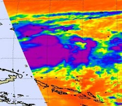
This infrared image of the eastern side of Tropical Storm Bopha was captured on Nov. 27 at 0241 UTC by the AIRS instrument that flies aboard NASA's Aqua satellite. The purple areas indicate coldest, highest cloud top temperatures that have the potential for dropping heavy rainfall.<br><br>Credit: NASA JPL/Ed Olsen<br>
The Atmospheric Infrared Sounder (AIRS) instrument that flies aboard NASA's Aqua satellite captured an infrared image of Tropical Storm Bopha on Nov. 27 at 0241 UTC that indicated a lot of power exists in the strengthening tropical storm. The AIRS image captured the eastern half of the tropical storm and showed a large area of very cold, very high cloud tops, where temperatures colder than -63 Fahrenheit (-52 Celsius) have the potential for dropping heavy rainfall.
On Nov. 27, the National Weather Service in Tiyan, Guam noted that “Residents of Satawal in Yap State should closely monitor the progress of Tropical Storm Bopha, as a tropical storm watch could be required Wednesday, Nov. 28.” A tropical storm warning remained in effect for Nukuoro in Pohnpei State and Lukunor in Chuuk State. A tropical storm watch remains in effect for Losap, the Chuuk Lagoon Islands and Puluwat in Chuuk State.
At 1500 UTC (10 a.m. EST/1 a.m. CHST local time) the center of Tropical Storm Bopha was located near latitude 4.7 degrees north and longitude 155.2 degrees east, only 55 miles north-northeast of Nukuoro. Bopha was also about105 miles southeast of Lukunor and 225 miles southeast of Losap. Tropical Storm Bopha was nearly stationary but the National Weather Service expects Bopha to start moving westward.
Bopha's maximum sustained winds have increased to 50 mph and Tropical Storm Bopha is expected to continue intensifying. Tropical storm force winds extend outward up to 45 miles from the center, making the storm almost 100 miles in diameter.
For specific information on effects to individual islands, visit the National Weather Service website: http://www.prh.noaa.gov/data/GUM/HLSPQ1.
Media Contact
More Information:
http://www.nasa.govAll latest news from the category: Earth Sciences
Earth Sciences (also referred to as Geosciences), which deals with basic issues surrounding our planet, plays a vital role in the area of energy and raw materials supply.
Earth Sciences comprises subjects such as geology, geography, geological informatics, paleontology, mineralogy, petrography, crystallography, geophysics, geodesy, glaciology, cartography, photogrammetry, meteorology and seismology, early-warning systems, earthquake research and polar research.


Newest articles

Silicon Carbide Innovation Alliance to drive industrial-scale semiconductor work
Known for its ability to withstand extreme environments and high voltages, silicon carbide (SiC) is a semiconducting material made up of silicon and carbon atoms arranged into crystals that is…

New SPECT/CT technique shows impressive biomarker identification
…offers increased access for prostate cancer patients. A novel SPECT/CT acquisition method can accurately detect radiopharmaceutical biodistribution in a convenient manner for prostate cancer patients, opening the door for more…

How 3D printers can give robots a soft touch
Soft skin coverings and touch sensors have emerged as a promising feature for robots that are both safer and more intuitive for human interaction, but they are expensive and difficult…

