NASA sees Tropical Storm Andrea cover half the East Coast
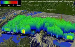
The TRMM image showed most of the rain was well ahead of the center of circulation. A broad area of light (shown in blue) to moderate rain (shown in green) covers the eastern half of Georgia and all of South Carolina. A cluster of heavier rain cells (shown in red) is poised to move onshore along the upper part of the South Carolina coast while at the same time the area right around the storm's center is nearly devoid of rain. At the time of this image, Andrea had weakened slightly to a moderate tropical storm with sustained winds reported at 50 mph.<br><br>Credit: SSAI/NASA, Hal Pierce<br>
NOAA's GOES-14 satellite captured a visible image of Andrea at 2:31 p.m. EDT. The center of Andrea was near Fayetteville, North Carolina at the time, and the bulk of the clouds and rain stretched from northwest to northeast of the center. Andrea's clouds extended over the Great Lakes and New England.
NASA Sees Andrea's Rainfall in 3-D
Earlier in the day at 02:35 UTC on June 7 (10:35 p.m. EDT, June 6), NASA's Tropical Rainfall Measuring Mission or TRMM satellite, captured an image of Andrea as the center was moving through northeast Florida about five hours after it made landfall. The image showed the horizontal distribution of rain intensity within the storm.
The rainfall rate image was created at NASA's Goddard Space Flight Center in Greenbelt, Md. by adding together data from two TRMM instruments. The rain rates in the center of the swath are from the TRMM Precipitation Radar (PR), and those in the outer swath are from the TRMM Microwave Imager (TMI). The rain rates are overlaid on infrared (IR) data from the TRMM Visible Infrared Scanner (VIRS).
The TRMM image showed most of the rain was well ahead of the center of circulation. A broad area of light to moderate rain covered the eastern half of Georgia and all of South Carolina. A cluster of heavier rain cells was poised to move onshore along the upper part of the South Carolina coast while at the same time the area right around the storm's center was nearly devoid of rain. At the time of the image, Andrea had weakened slightly to a moderate tropical storm with sustained winds reported at 50 mph.
Andrea's Location
At 2 p.m. EDT on June 7, Andrea was losing its tropical characteristics, but some thunderstorms were still forming near the center. Andrea's maximum sustained winds were near 45 mph (75 kph), and it was moving to the northeast at 28 mph (44 kph). Andrea's minimum central pressure was near 996 millibars.
At that time, there was a tropical storm warning in effect from north of Little River Inlet to Cape Charles Light, Virginia and for the Pamlico and Ablemarle Sounds.
Coastal areas are dealing with the most threats and that will be the case as Andrea continues her northward track. For example, the following watches and hazards were in effect for coastal Maryland and Virginia for the lower Chesapeake Bay south of New Port Comfort: A Flood Watch until midnight, a Beach Hazards Statement, High Rip Current Risk and Tornado Watch until 8 p.m. EDT.
Rainfall continues to be a big threat from Andrea. The tropical storm is expected to produce total rain accumulations of 2 to 4 inches from central and eastern North Carolina northeastward along the eastern seaboard into coastal Maine. According to the National Hurricane Center, tropical storm conditions will continue to spread northeastward along the U.S. east coast strong winds are possible elsewhere along the coast from Virginia to Atlantic Canada through early Sunday, June 9. A few tornadoes are possible over eastern portions of North Carolina and Virginia today.
The National Hurricane Center expects Andrea to turn toward the east-northeast late on June 8.
Media Contact
More Information:
http://www.nasa.govAll latest news from the category: Earth Sciences
Earth Sciences (also referred to as Geosciences), which deals with basic issues surrounding our planet, plays a vital role in the area of energy and raw materials supply.
Earth Sciences comprises subjects such as geology, geography, geological informatics, paleontology, mineralogy, petrography, crystallography, geophysics, geodesy, glaciology, cartography, photogrammetry, meteorology and seismology, early-warning systems, earthquake research and polar research.


Newest articles

“Nanostitches” enable lighter and tougher composite materials
In research that may lead to next-generation airplanes and spacecraft, MIT engineers used carbon nanotubes to prevent cracking in multilayered composites. To save on fuel and reduce aircraft emissions, engineers…

Trash to treasure
Researchers turn metal waste into catalyst for hydrogen. Scientists have found a way to transform metal waste into a highly efficient catalyst to make hydrogen from water, a discovery that…

Real-time detection of infectious disease viruses
… by searching for molecular fingerprinting. A research team consisting of Professor Kyoung-Duck Park and Taeyoung Moon and Huitae Joo, PhD candidates, from the Department of Physics at Pohang University…

