NASA sees Tropical Depression Talim becoming disorganized
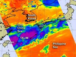
NASA's AIRS instrument (on the Aqua satellite) captured this infrared image of Tropical Depression Talim on June 21 at 3:29 a.m. EDT. The remaining scattered strongest thunderstorms have high, cold cloud tops of -63F (-52C). Credit: NASA/JPL, Ed Olsen<br>
NASA's Aqua satellite Atmospheric Infrared Sounder (AIRS) instrument captured an infrared image of Tropical Depression Talim on June 21 at 3:29 a.m. EDT. The imagery showed several areas of strong thunderstorms, but they're now scattered in nature as a result of the two factors.
As Talim moved over Taiwan and interacted with the land it weakened. Another factor that added to its rapid weakening was an increase in vertical wind shear (winds that batter a storm)from a nearby frontal system. The AIRS data did reveal that some of those scattered thunderstorms were still strong and had high, cold cloud tops of -63 Fahrenheit or -52 Celsius. Those thunderstorms were still dropping heavy rainfall and were occurring mostly over open water at the time of the AIRS image.
On June 21, 2012 at 0000 UTC (June 20 at 8 p.m. EDT/U.S.), Talim's maximum sustained winds were down to 25 knots (28.7 mph/46.3 kph). At that time, Talim was 100 nautical miles (115 miles/185 km) northeast of Taipei, Taiwan and moving east-northeast at 15 knots (17.2 mph/27.7 kph).
Forecasters at the Joint Typhoon Warning Center expect the depression to dissipate later today as it interacts with a frontal boundary that stretches from the Sea of Japan to the South China Sea. That system is expected to brush Kyushu Island, Japan.
Media Contact
More Information:
http://www.nasa.govAll latest news from the category: Earth Sciences
Earth Sciences (also referred to as Geosciences), which deals with basic issues surrounding our planet, plays a vital role in the area of energy and raw materials supply.
Earth Sciences comprises subjects such as geology, geography, geological informatics, paleontology, mineralogy, petrography, crystallography, geophysics, geodesy, glaciology, cartography, photogrammetry, meteorology and seismology, early-warning systems, earthquake research and polar research.


Newest articles

Machine learning algorithm reveals long-theorized glass phase in crystal
Scientists have found evidence of an elusive, glassy phase of matter that emerges when a crystal’s perfect internal pattern is disrupted. X-ray technology and machine learning converge to shed light…

Mapping plant functional diversity from space
HKU ecologists revolutionize ecosystem monitoring with novel field-satellite integration. An international team of researchers, led by Professor Jin WU from the School of Biological Sciences at The University of Hong…

Inverters with constant full load capability
…enable an increase in the performance of electric drives. Overheating components significantly limit the performance of drivetrains in electric vehicles. Inverters in particular are subject to a high thermal load,…

