NASA sees Tropical Depression 30W affecting central Philippines
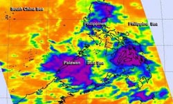
NASA's Aqua satellite passed over Tropical Depression 30W on Nov. 4 at 0529 UTC/12:29 a.m. EDT as it was exiting Visayas, central Philippines. The purple areas indicate coldest cloud tops with potential for heavy rainfall.<br><br>Credit: NASA JPL, Ed Olsen<br>
NASA's Aqua satellite passed over Tropical Depression 30W, known locally as “Wilma,” on Nov. 4 at 0529 UTC/12:29 a.m. EDT/1:29 p.m. Philippines local time as it was moving through Visayas, central Philippines.
The coldest cloud tops with potential for heavy rainfall were as cold as -63F/-52C and covered Visayas and extended west to Palawan. Palawan is an island province of the Philippines, west of Visayas.
The Philippine Atmospheric, Geophysical and Astronomical Services Administration (PAGASA) noted on Nov. 4 that the depression weakened to a low pressure area by 5 p.m. local time. At that time the center of the low was about 9.3 miles/15 km southwest of Tagbilaran City and was bringing rains and gusty winds to Visayas and Mindanao.
Local radar at 1:30 p.m. EST/18:30 UTC on Nov. 4/2:30 a.m. local time, Nov. 5, showed the heaviest precipitation had moved west of Visayas and was in part over northern Palawan as it headed further west into the South China Sea.
At 2 p.m. local time/1 a.m. EST, PAGASA issued the final bulletin on former Tropical Depression 30W. At that time, the center of the low pressure area was about 19.8 miles/32 km southeast of Tagbilaran City.
Now that former Tropical Depression 30W was wrapping up for the Philippines, residents of Visayas are keeping a close eye on Tropical Storm Haiyan moving their way from the east.
This isn't the end of Tropical Depression 30W, however. Now that it is in the warm waters of the South China Sea, the Joint Typhoon Warning Center expects it to re-strengthen. On Nov. 4 at 1500 UTC/10 a.m. EST, maximum sustained winds were near 30 knots/34.5 mph/55.5 kph and it had regained its status as a depression. It was located near 13.4 north and 93.4 east, about 267 nautical miles east of Puerto Princesa, Philippines. It was moving quickly to the west at 21 knots/24.1 mph/38.8 kph and is expected to reach tropical storm strength in the next day or two.
The Joint Typhoon Warning Center forecast brings the depression to southern Vietnam for a landfall sometime on Nov. 6.
Media Contact
More Information:
http://www.nasa.govAll latest news from the category: Earth Sciences
Earth Sciences (also referred to as Geosciences), which deals with basic issues surrounding our planet, plays a vital role in the area of energy and raw materials supply.
Earth Sciences comprises subjects such as geology, geography, geological informatics, paleontology, mineralogy, petrography, crystallography, geophysics, geodesy, glaciology, cartography, photogrammetry, meteorology and seismology, early-warning systems, earthquake research and polar research.


Newest articles

Properties of new materials for microchips
… can now be measured well. Reseachers of Delft University of Technology demonstrated measuring performance properties of ultrathin silicon membranes. Making ever smaller and more powerful chips requires new ultrathin…

Floating solar’s potential
… to support sustainable development by addressing climate, water, and energy goals holistically. A new study published this week in Nature Energy raises the potential for floating solar photovoltaics (FPV)…

Skyrmions move at record speeds
… a step towards the computing of the future. An international research team led by scientists from the CNRS1 has discovered that the magnetic nanobubbles2 known as skyrmions can be…

