NASA Sees Two Tropical Cyclones Competing in the Indian Ocean
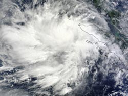
NASA’s Terra satellite captured this visible image of Tropical Cyclone Jamala in the southern Indian Ocean (bottom) and the much larger Tropical Cyclone One B (01B) in the Northern Indian Ocean on May 10 at 04:25 UTC (12:25 a.m. EDT). Credit: NASA Goddard MODIS Rapid Response Team <br>
The Moderate Resolution Imaging Spectroradiometer (MODIS) instrument that flies aboard NASA’s Terra satellite captured this visible image of compact Tropical Cyclone Jamala in the southern Indian Ocean and the much larger Tropical Cyclone One B (01B) in the Northern Indian Ocean on May 10 at 04:25 UTC (12:25 a.m. EDT).
On May 10 at 0900 UTC (5 a.m. EDT), Tropical Cyclone Jamala (formerly Cyclone 24S) had maximum sustained winds near 40 knots (46 mph/74 kph). It was centered near 8.7 south latitude and 86.2 east longitude, about 805 nautical miles (926.4 miles/1,491 km) east of Diego Garcia. Jamala is crawling to the south-southeast at 3 knots (3.4 mph/5.5 kph). Forecasters at the Joint Typhoon Warning Center expect Jamala to shift westward in movement and intensify up to hurricane strength.
A different look at Tropical Cyclone Jamala, using multi-spectral satellite imagery revealed a partially-exposed low-level circulation center and a large area of deep convection displaced over the western side of the storm.
North of the equator in the Northern Indian Ocean, newborn Tropical Cyclone 01B developed from low pressure System 92B. 01B formed near the northern tip of Sumatra. On May 10 at 0900 UTC Tropical Cyclone 01B had maximum sustained winds near 35 knots (40.2 mph/64.8 kph). It was located 1,052 nautical miles (1,211 miles/1,948 km) south of Chittagong, India, centered near 4.8 north latitude and 93.6 east longitude. Tropical Cyclone 01B was moving to the northeast at 4 knots (4.6 mph/7.4 kph) and is forecast to move northwest into the central Bay of Bengal.
Multi-spectral satellite imagery shows that the fragmented bands of thunderstorms that were seen yesterday, May 9, have now solidified, strengthened and have become tightly wrapped around 01B’s center.
Residents of northwestern Burma and eastern Bangladesh should keep a watch on Tropical Cyclone 01B. Forecasters at the Joint Typhoon Warning Center expect 01B to intensify into hurricane force and make landfall on May 14 or 15 in northwestern Burma and eastern Bangladesh.
Text Credit: Rob Gutro
NASA's Goddard Space Flight Center, Greenbelt, Md.
Media Contact
All latest news from the category: Earth Sciences
Earth Sciences (also referred to as Geosciences), which deals with basic issues surrounding our planet, plays a vital role in the area of energy and raw materials supply.
Earth Sciences comprises subjects such as geology, geography, geological informatics, paleontology, mineralogy, petrography, crystallography, geophysics, geodesy, glaciology, cartography, photogrammetry, meteorology and seismology, early-warning systems, earthquake research and polar research.


Newest articles

Superradiant atoms could push the boundaries of how precisely time can be measured
Superradiant atoms can help us measure time more precisely than ever. In a new study, researchers from the University of Copenhagen present a new method for measuring the time interval,…

Ion thermoelectric conversion devices for near room temperature
The electrode sheet of the thermoelectric device consists of ionic hydrogel, which is sandwiched between the electrodes to form, and the Prussian blue on the electrode undergoes a redox reaction…

Zap Energy achieves 37-million-degree temperatures in a compact device
New publication reports record electron temperatures for a small-scale, sheared-flow-stabilized Z-pinch fusion device. In the nine decades since humans first produced fusion reactions, only a few fusion technologies have demonstrated…

