NASA sees Tropical Cyclone Narelle intensifying
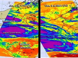
These two AIRS infrared images of Tropical Cyclone Narelle were captured on Jan. 8 at 1723 UTC and Jan. 9 at 0541 UTC. The very cold cloud top temperatures of -63F (-52C) appear in purple, indicating high, powerful thunderstorms with heavy rainfall.<br><br>Credit: NASA JPL, Ed Olsen<br>
The Australian Bureau of Meteorology (ABM) issued the following watch and warnings for Narelle on Jan. 9: A cyclone watch is in effect for coastal areas from Whim Creek to Coral Bay. A Blue alert is in effect for coastal and island communities from Whim Creek to Mardie, including Wickham, Roebourne, Point Sampson, Karratha and Dampier.
The ABM noted on its tropical cyclone warning website today, Jan. 9, that Tropical Cyclone Narelle is expected to strengthen as it moves toward the Northwest Cape. ABM said that gales with gusts to 100 kph are expected to develop in coastal areas between Whim Creek and Onslow including the Karratha area Friday morning (Jan. 11), then extend west to Exmouth and Coral Bay later Friday or early Saturday (Jan. 12). Thunderstorm activity is forecast to increase along the Pilbara coastline on Jan. 11, where some areas may experience heavy rainfall. On Saturday, winds are expected to increase along the western Pilbara coast.
NASA's Aqua satellite has been providing data to forecasters at the Joint Typhoon Warning Center. The Atmospheric Infrared Sounder (AIRS) instrument aboard Aqua has been capturing infrared and near infrared data that have shown colder cloud top temperatures and a more organized center of circulation in Narelle over the two days of Jan. 8 and 9.
The two AIRS infrared images of Tropical Cyclone Narelle were captured on Jan. 8 at 1723 UTC and Jan. 9 at 0541 UTC (12:41 a.m. EST/U.S.) and showed cold cloud top temperatures of -63F (-52C) indicating high, powerful thunderstorms with heavy rainfall over a large area. Infrared satellite imagery also showed tightly-curved, deep convective banding of thunderstorms wrapping into a well-defined low-level circulation center that was evident on AIRS near infrared imagery on Jan. 9 at 0541 UTC (12:41 a.m. EST/U.S.).
Near-infrared imagery looks like a visible image. That near-infrared image showed a tight circulation center with a large band of thunderstorms wrapping around from the south. Western Australia is seen southeast of Narelle. All of the AIRS imagery was created at NASA's Jet Propulsion Laboratory in Pasadena, Calif.
On Jan. 9 at 1500 UTC (10 a.m. EST/U.S.), Tropical Cyclone Narelle was located near 13.5 south latitude and 115.9 east longitude, about 525 nautical miles (604.2 miles/972.3 km) north-northeast of Learmonth, Australia. Narelle was moving to the southwest at 6 knots (7 mph/11.1 kph) and generating waves up to 26 feet high (7.9 meters).
Narelle's maximum sustained winds were near 70 knots (80.5 mph/129.6 kph). Cyclone-force winds extend up to 25 nautical miles (28.7 miles/ 46.3 km) from the center, while tropical-storm-force winds extend up to 85 nautical miles (97.8 miles/157.4 km) from the center.
Tropical Cyclone Narelle is expected to continue moving slowly southwest along the northwestern edge of a strong subtropical ridge (elongated area) of high pressure. That ridge is currently located over Western Australia.
Narelle is expected to continue intensifying over the next two days as it moves closer to the coastline. The Joint Typhoon Warning Center noted that after passing Cape Leveque Narelle will start to weaken. In the meantime, residents in the warning and watch areas should expect deteriorating conditions.
Media Contact
More Information:
http://www.nasa.govAll latest news from the category: Earth Sciences
Earth Sciences (also referred to as Geosciences), which deals with basic issues surrounding our planet, plays a vital role in the area of energy and raw materials supply.
Earth Sciences comprises subjects such as geology, geography, geological informatics, paleontology, mineralogy, petrography, crystallography, geophysics, geodesy, glaciology, cartography, photogrammetry, meteorology and seismology, early-warning systems, earthquake research and polar research.


Newest articles

A new look at the consequences of light pollution
GAME 2024 begins its experiments in eight countries. Can artificial light at night harm marine algae and impair their important functions for coastal ecosystems? This year’s project of the training…

Silicon Carbide Innovation Alliance to drive industrial-scale semiconductor work
Known for its ability to withstand extreme environments and high voltages, silicon carbide (SiC) is a semiconducting material made up of silicon and carbon atoms arranged into crystals that is…

New SPECT/CT technique shows impressive biomarker identification
…offers increased access for prostate cancer patients. A novel SPECT/CT acquisition method can accurately detect radiopharmaceutical biodistribution in a convenient manner for prostate cancer patients, opening the door for more…

