NASA sees Tropical Cyclone Narelle approaching Western Australia coast
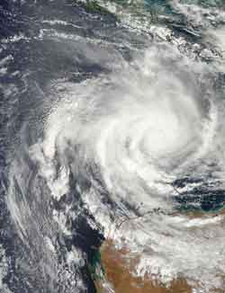
This visible image of Tropical Cyclone Narelle was captured by the MODIS instrument aboard NASA's Aqua satellite on Jan. 10, 2013, at 0625 UTC. Narelle developed the tropical cyclone signature shape with a tight rounded center and bands of thunderstorms wrapping around.<br><br>Credit: NASA Goddard MODIS Rapid Response Team<br>
Watches and Warnings are posted for the western coast of Western Australia over the next several days as Narelle continues to move on a southerly track, where it is expected to remain at sea, but parallel the coast.
Current Australian warnings include: a Cyclone Warning is in effect for coastal areas from Whim Creek to Coral Bay, including Karratha, Dampier, Onslow and Exmouth. A Cyclone Watch is in effect for coastal areas from Coral Bay to Cape Cuvier.
A Blue alert is in effect for the coastal and island communities from Whim Creek to Mardie, including Wickham, Roebourne, Point Sampson, Karratha and DampiFor updated warnings and watches, visit the Australian Bureau of Meteorology web page: http://www.bom.gov.au/
australia/warnings/index.shtml.
When NASA's Aqua satellite passed over Narelle on Jan. 9 at 1811 UTC (1:11 p.m. EST/2:11 a.m. on Jan. 10, local time, Perth, Australia), the Atmospheric Infrared Sounder (AIRS) instrument captured data on the storm in infrared light. Infrared light shows temperature, and cloud top temperatures can indicate if clouds are reaching higher in the atmosphere (strengthening) or lower (weakening). AIRS data showed that the largest area of powerful thunderstorms were around the center, north and northwest of the center of circulation, an indication of where the heaviest rain was falling.
Another that flies aboard NASA's Aqua satellite called the Moderate Resolution Imaging Spectroradiometer (MODIS) instrument captured a visible image of Tropical Cyclone Narelle as it was approaching the northern coast of Western Australia. The image was taken on Jan. 10, 2013 at 0625 UTC (1:25 a.m. EST/2:25 p.m. local time, Perth, Australia). The MODIS image revealed that Narelle developed the signature shape of a tropical cyclone with a tight rounded center and bands of thunderstorms wrapping into the center.
On Jan. 10 at 1500 UTC (10 a.m. EST/11 p.m. local time, Perth), Tropical Cyclone Narelle had maximum sustained winds near 80 knots (92 mph/148.2 kph). It was centered near 16.5 south latitude and 114.7 east longitude, about 370 nautical miles north of Learmonth, Australia. Narelle has been moving south-southwest at 10 knots (11.5 mph/18.5 kph). Narelle is churning up rough seas, as high as 32 feet (9.7 meters), which will likely cause coastal erosion and flooding. Narelle is expected to continue moving to the south-southwest toward Northwest Cape and gradually intensify.
Infrared imagery, such as what AIRS provides shows that a new feeder band of thunderstorms has formed to the south of the center. Infrared data showed that cloud tops around the center have cooled, indicating convection (rising air forming the thunderstorms that make up the cyclone) has strengthened, and cloud tops are higher and the storms more powerful. Microwave satellite data, which can see through clouds, showed that an eye was forming in the center. The JTWC forecasters call for Narelle to continue intensifying as it moves south, and peak around 115 knots (132.3 mph/213 kph) sometime on Jan. 12 before weakening again.
New forecast guidance from the Joint Typhoon Warning Center (JTWC) now calls for the west coast of Western Australia to experience Tropical Cyclone Narelle's rainfall, gusty winds and rough surf. The JTWC forecast now takes Narelle close to the coast from north of Learmonth to the peninsula south of Perth, where it is now expected to make landfall in the South West region of Western Australia on Jan. 15 after tracking south through Geographe Bay.
Media Contact
More Information:
http://www.nasa.govAll latest news from the category: Earth Sciences
Earth Sciences (also referred to as Geosciences), which deals with basic issues surrounding our planet, plays a vital role in the area of energy and raw materials supply.
Earth Sciences comprises subjects such as geology, geography, geological informatics, paleontology, mineralogy, petrography, crystallography, geophysics, geodesy, glaciology, cartography, photogrammetry, meteorology and seismology, early-warning systems, earthquake research and polar research.


Newest articles

Bringing bio-inspired robots to life
Nebraska researcher Eric Markvicka gets NSF CAREER Award to pursue manufacture of novel materials for soft robotics and stretchable electronics. Engineers are increasingly eager to develop robots that mimic the…

Bella moths use poison to attract mates
Scientists are closer to finding out how. Pyrrolizidine alkaloids are as bitter and toxic as they are hard to pronounce. They’re produced by several different types of plants and are…

AI tool creates ‘synthetic’ images of cells
…for enhanced microscopy analysis. Observing individual cells through microscopes can reveal a range of important cell biological phenomena that frequently play a role in human diseases, but the process of…

