NASA sees Tropical Cyclone Gillian reborn near Java
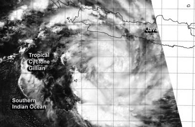
NASA's Aqua satellite captured Tropical Cyclone Gillian's rebirth near Java on March 21 at 06:55 UTC. Credit: NRL/NASA
Java is highly populated island of Indonesia that includes the capital city of Jakarta. Java is divided into four provinces, East, West and Central Java and Banten. There are also two special regions of Java called Jakarta and Yogyakarta.
The MODIS instrument that flies aboard Aqua captured a visible image of Gillian on March 21 at 06:55 UTC/2:55 a.m. EDT.
The image showed bands of thunderstorms wrapping around the center of circulation that stretched from the north to the east and southwest. Only the northwestern quadrant appeared to have a fragmented band.
The NOAA-19 polar orbiting satellite showed that Gillian is a symmetric and compact system with improved central convection.
Gillian initially formed on March 10 in the northern Gulf of Carpentaria, part of the Southern Pacific Ocean. After a brief landfall in Queensland's Cape York Peninsula it weakened to a remnant low, moved northwest and entered the Southern Indian Ocean where it just re-formed into a tropical storm.
At 0900 UTC/5 a.m. EDT, Tropical Cyclone Gillian's maximum sustained winds were near 35 knots/40 mph/62 kph. It was centered near 9.6 south and 108.2 east, just south of Java and about 834 nautical miles/959.8 miles/1,545 km north-northwest of Learmonth, Australia. Gillian was moving to the west at 16 knots/18.4 mph/ 29.6 kph.
The Indonesian Tropical Cyclone Warning Center in Jakarta has issued watches and warnings across parts of Java and Sumatra for heavy rain and rough surf.
Gillian is expected to move west and once past Christmas Island, the Australian Bureau of Meteorology and the Joint Typhoon Warning Center expect it to move southwest while intensifying to hurricane-force over open waters of the Southern Indian Ocean.
Media Contact
More Information:
http://www.nasa.govAll latest news from the category: Earth Sciences
Earth Sciences (also referred to as Geosciences), which deals with basic issues surrounding our planet, plays a vital role in the area of energy and raw materials supply.
Earth Sciences comprises subjects such as geology, geography, geological informatics, paleontology, mineralogy, petrography, crystallography, geophysics, geodesy, glaciology, cartography, photogrammetry, meteorology and seismology, early-warning systems, earthquake research and polar research.


Newest articles

Machine learning algorithm reveals long-theorized glass phase in crystal
Scientists have found evidence of an elusive, glassy phase of matter that emerges when a crystal’s perfect internal pattern is disrupted. X-ray technology and machine learning converge to shed light…

Mapping plant functional diversity from space
HKU ecologists revolutionize ecosystem monitoring with novel field-satellite integration. An international team of researchers, led by Professor Jin WU from the School of Biological Sciences at The University of Hong…

Inverters with constant full load capability
…enable an increase in the performance of electric drives. Overheating components significantly limit the performance of drivetrains in electric vehicles. Inverters in particular are subject to a high thermal load,…

