NASA sees Super Typhoon Nepartak approaching Taiwan
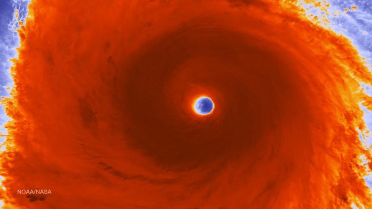
The VIIRS instrument aboard NASA-NOAA-DOD's Suomi NPP satellite captured a close-up image of the storm's eye surrounded by powerful thunderstorms. Credit: NOAA/NASA/DOD
The RapidScat instrument that flies aboard the International Space Station has been analyzing the winds around Super typhoon Nepartak. RapidScat is a scatterometer that can measure wind speeds over open ocean surfaces. RapidScat passed directly over Super Typhoon Nepartak on July 6 and read wind speeds upwards of 27 meters per second (60.4 mph/97.2 kph).
Tropical Storm force winds of 34 knots (39 mph/63 kph) or higher were occurring within 135 to 145 miles of the center, while typhoon-force winds of 64 knots (74 mph/119 kph) or higher occur within 45 to 60 miles of the center.
On July 7 at 02:30 UTC (July 6 at 10:30 p.m. EDT) the MODIS instrument aboard NASA's Terra satellite captured a visible light image of Super Typhoon Nepartak approaching Taiwan. The image showed a clear eye and bands of thunderstorms wrapping into the low-level center.
On July 7, 2016, at 12:45 a.m. EDT, the Visible Infrared Imaging Radiometer Suite (VIIRS) instrument aboard NASA-NOAA-DOD's Suomi NPP satellite captured a close-up image of the storm's eye surrounded by powerful thunderstorms.
The Joint Typhoon Warning Center (JTWC) said that Nepartak appears to have weakened slightly during the early morning of July 7 (EDT) with cooling eye temperatures evident in infrared satellite data.
The Philippines issued some warnings for July 7: Public storm warning signal #2 is raised in Batanes group of islands and Public storm warning signal #1 is raised in Babuyan group of Islands. In the Philippines Nepartak is referred to as Butchoy.
At 1500 UTC (11 a.m. EDT) on July 7, Nepartak was still a super typhoon. Maximum sustained winds were near 140 knots (161.1 mph/259.3 kph). It was located near 22.0 degrees north latitude and 122.6 degrees east longitude, about 196 nautical miles south-southeast of Taipei, Taiwan. Nepartak was moving to the west-northwest at 8 knots (9.2 mph/14.8 kph).
Taiwan's Central Weather Bureau posted Typhoon Warnings on July 7. For details and graphics visit: http://www.
Nepartak is expected to cross southern Taiwan from southeast to northwest. Landfall is expected around July 8 around 0000 UTC (July 7 at 8 p.m. EDT). Nepartak has started on a weakening trend as it approaches Taiwan. The Joint Typhoon Warning Center expects the storm to move through the Taiwan Straits and make landfall in eastern China around July 9 around 0000 UTC (8 p.m. EDT) where it will dissipate.
Media Contact
All latest news from the category: Earth Sciences
Earth Sciences (also referred to as Geosciences), which deals with basic issues surrounding our planet, plays a vital role in the area of energy and raw materials supply.
Earth Sciences comprises subjects such as geology, geography, geological informatics, paleontology, mineralogy, petrography, crystallography, geophysics, geodesy, glaciology, cartography, photogrammetry, meteorology and seismology, early-warning systems, earthquake research and polar research.


Newest articles

Silicon Carbide Innovation Alliance to drive industrial-scale semiconductor work
Known for its ability to withstand extreme environments and high voltages, silicon carbide (SiC) is a semiconducting material made up of silicon and carbon atoms arranged into crystals that is…

New SPECT/CT technique shows impressive biomarker identification
…offers increased access for prostate cancer patients. A novel SPECT/CT acquisition method can accurately detect radiopharmaceutical biodistribution in a convenient manner for prostate cancer patients, opening the door for more…

How 3D printers can give robots a soft touch
Soft skin coverings and touch sensors have emerged as a promising feature for robots that are both safer and more intuitive for human interaction, but they are expensive and difficult…

