NASA Sees Sanba Become a Super Typhoon
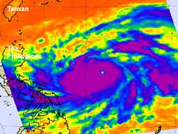
NASA's Aqua satellite passed over Super Typhoon Sanba on Sept. 13 at 12:47 a.m. EDT. AIRS infrared data found an eye (the yellow dot in the middle of the purple area) about 20 nautical miles wide, surrounded by a thick area of strong thunderstorms (purple) with very cold cloud temperatures. Credit: NASA/JPL, Ed Olsen<br>
NASA's Aqua satellite passed over Super Typhoon Sanba on Sept. 13 at 0447 UTC (12:47 a.m. EDT). The Atmospheric Infrared Sounder (AIRS) instrument captured an infrared image of Sanba and found an eye about 20 nautical miles (23 miles/37 km) wide, surrounded by a thick area of strong convection (rising air that forms the thunderstorms that make up the storm) and strong thunderstorms.
Forecasters at the Joint Typhoon Warning center noted that the AIRS imagery showed that there was “no banding outside of this ring, consistent with an annular typhoon.”
On Sept. 13 at 1500 UTC (11 a.m. EDT), Sanba's maximum sustained winds were near 135 knots (155 mph/250 kmh). Sanba had higher gusts into the Category 5 typhoon category. The Saffir-Simpson scale was slightly revised earlier in 2012, so a Category 4 typhoon/hurricane has maximum sustained winds from 113 to 136 knots (130 to 156 mph /209 to 251 kmh). A Category 5 typhoon's maximum sustained winds begin at 137 knots (157 mph /252 kmh).
Sanba was located about 600 nautical miles (690 miles/1,111 km) south of Kadena Air Base, near 16.8 North latitude and 129.5 East longitude. It was moving to the north at 9 knots (10.3 mph/16.6 kmh) and generating wave heights of 40 feet.
Sanba is expected to continue on a north-northwesterly track through the western North Pacific and move through the East China Sea, passing close to Kadena Air Base, Okinawa, Japan on Sept. 15.
Text Credit: Rob Gutro
NASA Goddard Space Flight Center, Greenbelt, Md.
Media Contact
All latest news from the category: Earth Sciences
Earth Sciences (also referred to as Geosciences), which deals with basic issues surrounding our planet, plays a vital role in the area of energy and raw materials supply.
Earth Sciences comprises subjects such as geology, geography, geological informatics, paleontology, mineralogy, petrography, crystallography, geophysics, geodesy, glaciology, cartography, photogrammetry, meteorology and seismology, early-warning systems, earthquake research and polar research.


Newest articles

Superradiant atoms could push the boundaries of how precisely time can be measured
Superradiant atoms can help us measure time more precisely than ever. In a new study, researchers from the University of Copenhagen present a new method for measuring the time interval,…

Ion thermoelectric conversion devices for near room temperature
The electrode sheet of the thermoelectric device consists of ionic hydrogel, which is sandwiched between the electrodes to form, and the Prussian blue on the electrode undergoes a redox reaction…

Zap Energy achieves 37-million-degree temperatures in a compact device
New publication reports record electron temperatures for a small-scale, sheared-flow-stabilized Z-pinch fusion device. In the nine decades since humans first produced fusion reactions, only a few fusion technologies have demonstrated…

