NASA sees remnants of Tropical Depression Peipah over Southern Philippines
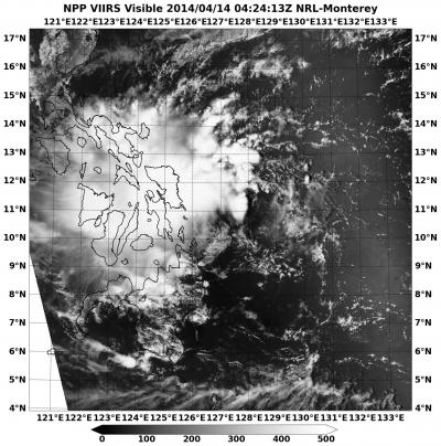
This visible image of Tropical Depression Peipah's remnants over the southern and central Philippines was taken from the VIIRS instrument aboard NASA-NOAA's Suomi NPP satellite on April 14 at 4:24 UTC/12:24. Credit: NRL/NASA/NOAA
NASA-NOAA's Suomi NPP satellite captured an image that showed Peipah's clouds covering the Visayas and Mindanao regions of the country.
The VIIRS instrument aboard NASA-NOAA's Suomi NPP satellite captured a visible look at the remnant clouds associated with former Tropical Depression Peipah on April 14 at 4:24 UTC/12:24 a.m. EDT.
The Visible Infrared Imaging Radiometer Suite (VIIRS) instrument collects visible and infrared imagery and global observations of land, atmosphere, cryosphere and oceans.
Peipah is a broad area of low pressure and its remnant clouds covered the central region of the Philippines called the Visayas region, and Mindanao, the southern region. Microwave satellite imagery confirmed that the low-level part of the storm is still poorly defined and convection (rising air that builds thunderstorms that make up a tropical cyclone) has not improved.
On April 14 at 0900 UTC/5 a.m. EDT, Peipah's remnants were centered near 9.7 north latitude and 130.8 east longitude, about 360 nautical miles/414 miles/666.7 km northwest of Zamboanga, Philippines. Maximum sustained winds were estimated as high as 20 knots/23.0 mph/37.2 kph.
According to the Joint Typhoon Warning Center, Peipah's remnants have a medium chance for regenerating in the next couple of days as it moves slowly in a westerly direction.
Media Contact
More Information:
http://www.nasa.govAll latest news from the category: Earth Sciences
Earth Sciences (also referred to as Geosciences), which deals with basic issues surrounding our planet, plays a vital role in the area of energy and raw materials supply.
Earth Sciences comprises subjects such as geology, geography, geological informatics, paleontology, mineralogy, petrography, crystallography, geophysics, geodesy, glaciology, cartography, photogrammetry, meteorology and seismology, early-warning systems, earthquake research and polar research.


Newest articles

Bringing bio-inspired robots to life
Nebraska researcher Eric Markvicka gets NSF CAREER Award to pursue manufacture of novel materials for soft robotics and stretchable electronics. Engineers are increasingly eager to develop robots that mimic the…

Bella moths use poison to attract mates
Scientists are closer to finding out how. Pyrrolizidine alkaloids are as bitter and toxic as they are hard to pronounce. They’re produced by several different types of plants and are…

AI tool creates ‘synthetic’ images of cells
…for enhanced microscopy analysis. Observing individual cells through microscopes can reveal a range of important cell biological phenomena that frequently play a role in human diseases, but the process of…

