NASA sees little rainfall in Tropical Depression Flossie
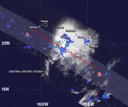
The TRMM satellite flew over Flossie on July 30, 2013, at 07:17 UTC and saw a small area of heavy rain (red) west of the center of circulation. Most of the other rainfall was light (blue) and moderate (green).<br><br>Credit: NASA/SSAI, Hal Pierce<br>
The Tropical Rainfall Measuring Mission, or TRMM, satellite flew over Flossie on July 30 at 07:17 UTC (3:17 a.m. EDT) and saw a small area of heavy rain west of the center of circulation. TRMM data showed that the rest of Flossie's rainfall was light to moderate. TRMM is managed by both NASA and the Japan Aerospace Exploration Agency.
At 5 a.m. EDT on July 30 (11 p.m. HST on July 29), the center of Tropical Depression Flossie was located near latitude 22.2 north, longitude 158.3 west. That put Flossie's center about 270 miles (435 km) northwest of Hilo and 65 miles (110 km) north-northwest of Honolulu.
The National Oceanic and Atmospheric Administration's Central Pacific Hurricane Center noted that the depression is moving toward the west-northwest near 18 mph (30 kph) and is expected to continue in that direction for the next two days. Flossie's maximum sustained winds have dropped to near 35 mph (55 kph) and the CPHC forecasts continued weakening over the next two days. Estimated minimum central pressure is 1009 millibars.
Flossie is moving into a somewhat less hostile environment. As TRMM data showed, there is no active convection (rising air forming the thunderstorms that make up the tropical cyclone) remaining near the system center Flossie. Forecasters at CPHC believe that Flossie may be “too far gone” to recover and re-strengthen. Flossie is forecast to remain a depression through 24 hours, become a remnant low in 36 hours, and dissipate by 72 hours.
The CPHC expects gusty winds will likely continue today as Flossie continues moving west-northwest.Locally heavy rainfall is expected to continue through the night-time hours on Tuesday, July 30, local time. This rainfall could cause life-threatening flash floods and mud slides.
Meanwhile, CPHC notes that dangerous high surf will continue to affect east facing shores on July 30. Large surf is expected to continue from Maui to Niihau before subsiding tonight, July 30.
The National Hurricane Center expects Tropical Depression Flossie to continue moving through the Hawaiian Islands today, July 30, reaching Maro Reef, Hawaii by Wednesday, July 31. Maro Reef is a mostly submerged coral atoll in the northwestern Hawaiian Islands, about 850 miles (1,370 km) northwest of Honolulu.
Media Contact
More Information:
http://www.nasa.govAll latest news from the category: Earth Sciences
Earth Sciences (also referred to as Geosciences), which deals with basic issues surrounding our planet, plays a vital role in the area of energy and raw materials supply.
Earth Sciences comprises subjects such as geology, geography, geological informatics, paleontology, mineralogy, petrography, crystallography, geophysics, geodesy, glaciology, cartography, photogrammetry, meteorology and seismology, early-warning systems, earthquake research and polar research.


Newest articles

Silicon Carbide Innovation Alliance to drive industrial-scale semiconductor work
Known for its ability to withstand extreme environments and high voltages, silicon carbide (SiC) is a semiconducting material made up of silicon and carbon atoms arranged into crystals that is…

New SPECT/CT technique shows impressive biomarker identification
…offers increased access for prostate cancer patients. A novel SPECT/CT acquisition method can accurately detect radiopharmaceutical biodistribution in a convenient manner for prostate cancer patients, opening the door for more…

How 3D printers can give robots a soft touch
Soft skin coverings and touch sensors have emerged as a promising feature for robots that are both safer and more intuitive for human interaction, but they are expensive and difficult…

