NASA Sees Rainfall Quickly Fade in Dying Depression 33W
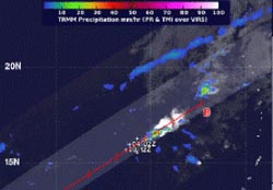
NASA's TRMM satellite captured this image of Tropical Depression 33W's sparse rainfall on Dec. 4 at 1045 UTC. There were two isolated areas of heavy (red) rainfall. <br>Image Credit: NASA/SSAI, Hal Pierce<br>
Tropical Depression 33W or TD 33W had weakened and TRMM showed only two isolated areas of heavy rainfall in the fragmented system.
At 0300 UTC on December 4/10 p.m. EST December 3, the Joint Typhoon Warning Center had already issued its final advisory on TD 33W. At that time, TD 33W's maximum sustained winds had already diminished to 25 knots/28.7 mph/46.3 kph.
The center of the disorganized depression was located near 15.5 north and 139.1 east, about 354 nautical miles west-northwest of Andersen Air Force Base, Guam. It was moving to the southeast at 4 knots/4.6 mph/7.4 kph.
NASA's Tropical Rainfall Measuring Mission satellite known as TRMM measured the rainfall rates occurring within TD 33W on December 4 at 1045 UTC/5:45 a.m. EST. Two isolated areas within the circulation of the depression revealed heavy rainfall where rain was falling at 2 inches/50 mm per hour.
The remaining rainfall in the system was scattered and light, but no rainfall around the center of circulation. Multispectral satellite imagery showed that the low-level circulation center was exposed to outside winds.
Vertical wind shear has literally taken the wind out of the depression. Wind shear increased to more than 30 knots/34.5 mph/55.5 kph and was pounding the depression. TD 33W is expected to move to the northeast and dissipate over the next day.
Text credit: Rob Gutro
NASA's Goddard Space Flight Center
Media Contact
All latest news from the category: Earth Sciences
Earth Sciences (also referred to as Geosciences), which deals with basic issues surrounding our planet, plays a vital role in the area of energy and raw materials supply.
Earth Sciences comprises subjects such as geology, geography, geological informatics, paleontology, mineralogy, petrography, crystallography, geophysics, geodesy, glaciology, cartography, photogrammetry, meteorology and seismology, early-warning systems, earthquake research and polar research.


Newest articles

Silicon Carbide Innovation Alliance to drive industrial-scale semiconductor work
Known for its ability to withstand extreme environments and high voltages, silicon carbide (SiC) is a semiconducting material made up of silicon and carbon atoms arranged into crystals that is…

New SPECT/CT technique shows impressive biomarker identification
…offers increased access for prostate cancer patients. A novel SPECT/CT acquisition method can accurately detect radiopharmaceutical biodistribution in a convenient manner for prostate cancer patients, opening the door for more…

How 3D printers can give robots a soft touch
Soft skin coverings and touch sensors have emerged as a promising feature for robots that are both safer and more intuitive for human interaction, but they are expensive and difficult…

