NASA sees quick development of Hurricane Dora
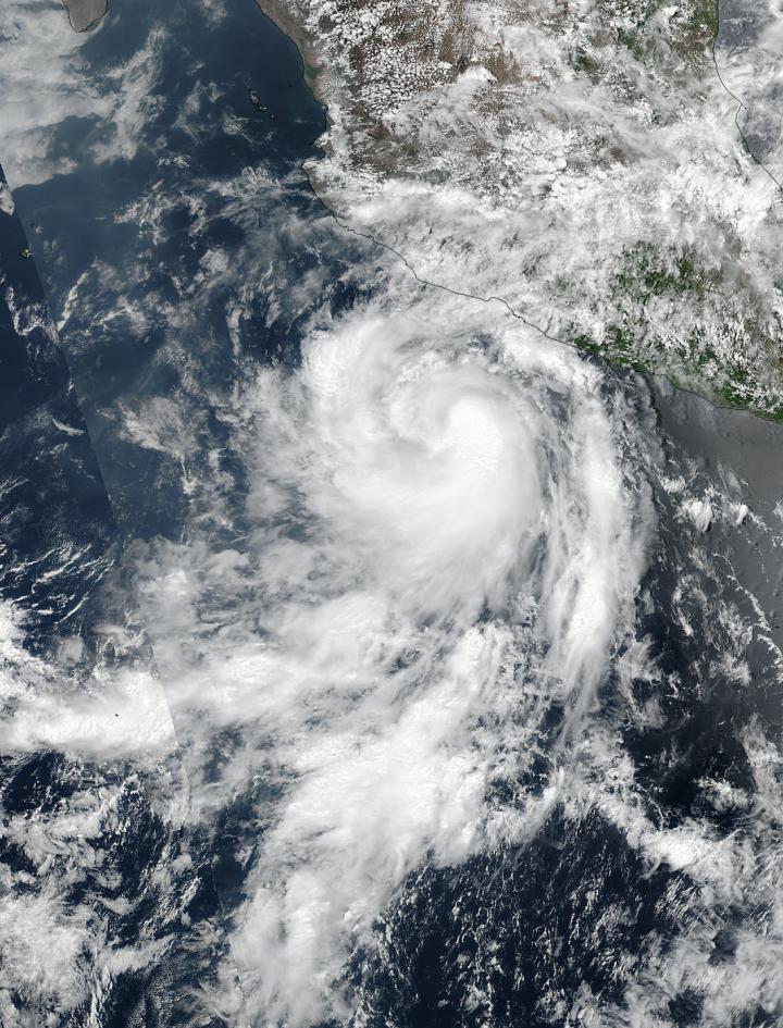
On June 25, NASA-NOAA's Suomi NPP satellite captured this visible image of Tropical Storm Dora in the Eastern Pacific. Credits: NASA/NOAA
Tropical Depression Dora developed around 11 p.m. EDT on Saturday, June 24 about 180 miles (290 km) south of Acapulco, Mexico. By 5 a.m. EDT on June 25, the depression had strengthened into a tropical storm and was named Dora.
At 19:36 UTC (3:36 p.m. EDT), the Visible Infrared Imaging Radiometer Suite (VIIRS) instrument aboard NASA-NOAA's Suomi NPP satellite provided a visible-light image of the storm. The VIIRS imagery showed well-defined convective spiral bands of thunderstorms with a developing central dense overcast or CDO cloud feature.
Seven and a half hours later, Dora showed signs of better organization. At 11 p.m. EDT, the National Hurricane Center or NHC noted “Dora's cloud pattern has continued to quickly improve this evening. Several well-defined spiral bands wrap around the center and the CDO has become more symmetric and expanded since the previous advisory.”
At 5 a.m. EDT on Monday, June 26, Dora became the first hurricane of the Eastern Pacific Ocean hurricane season. Satellite data indicate that maximum sustained winds have increased to near 80 mph (130 kph) with higher gusts.
The NHC said the eye of Hurricane Dora was located near latitude 16.7 degrees North and longitude 105.3 degrees West. That's about 170 miles (275 km) south-southwest of Manzanillo, Mexico. Dora was moving toward the west-northwest near 13 mph (20 kph), and the NHC forecast said that general motion with some decrease in forward speed is expected over the next 48 hours. On the forecast track, the center of Dora is expected to remain offshore of the coast of southwestern Mexico.
Some strengthening is likely today before weakening is forecast to begin on Tuesday, June 27. For updated forecasts, visit: http://www.
Media Contact
All latest news from the category: Earth Sciences
Earth Sciences (also referred to as Geosciences), which deals with basic issues surrounding our planet, plays a vital role in the area of energy and raw materials supply.
Earth Sciences comprises subjects such as geology, geography, geological informatics, paleontology, mineralogy, petrography, crystallography, geophysics, geodesy, glaciology, cartography, photogrammetry, meteorology and seismology, early-warning systems, earthquake research and polar research.


Newest articles

Bringing bio-inspired robots to life
Nebraska researcher Eric Markvicka gets NSF CAREER Award to pursue manufacture of novel materials for soft robotics and stretchable electronics. Engineers are increasingly eager to develop robots that mimic the…

Bella moths use poison to attract mates
Scientists are closer to finding out how. Pyrrolizidine alkaloids are as bitter and toxic as they are hard to pronounce. They’re produced by several different types of plants and are…

AI tool creates ‘synthetic’ images of cells
…for enhanced microscopy analysis. Observing individual cells through microscopes can reveal a range of important cell biological phenomena that frequently play a role in human diseases, but the process of…

