NASA sees newborn Tropical Storm Evan causing trouble for American Samoa
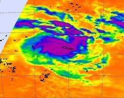
The AIRS instrument aboard NASA's Aqua satellite captured an infrared image of newborn Tropical Storm Evan over American Samoa on Dec. 12, 2012, at 12:47 UTC (7:47 a.m. EST). The strongest thunderstorms (purple) appear around the center of circulation and in a band of thunderstorms north and east of the center.<br><br>Credit: NASA/JPL, Ed Olsen<br>
Tropical Storm Evan caused regional warnings to be posted on Dec. 12. In American Samoa, a gale warning and storm watch are in effect for Tutuila, Aunuu, Manua and Swains Island.
The Atmospheric Infrared Sounder (AIRS) instrument aboard NASA's Aqua satellite captured an infrared image of newborn Tropical Storm Evan over American Samoa on Dec. 12, 2012 at 12:47 UTC (7:47 a.m. EST). The strongest thunderstorms with cloud top temperatures exceeding -63F (-52C) appeared around the center of circulation and in a band of thunderstorms north and east of the center. Cloud top temperatures that cold indicate the highest, strongest storms with the heaviest rainfall within the tropical cyclone.
In addition to NASA's Aqua satellite, NOAA's GOES-15 satellite captured a visible image of newborn Tropical Storm Evan on Dec. 12, 2012 at 1500 UTC (10 a.m. EST) that showed a rounded storm.
At 1500 UTC (10 a.m. EST), Tropical Storm Evan had maximum sustained winds near 50 knots (57.5 mph/92.6 kph). Those tropical-storm-force winds extended 45 nautical miles (51.7 miles/83.3 km) from the center. The center of Evan was located near 13.9 south latitude and 173.2 west longitude, about 145 nautical miles (170 miles/268.5 km) west of Pago Pago, American Samoa. Pago Pago is the capital of American Samoa.
The National Weather Service (NWS) in Pago Pago, American Samoa noted in their forecast for Tutuila and Aunuu that the strongest winds are likely to occur there today, Dec. 12, and Thursday, Dec. 13. The NWS forecast calls for northwest winds between 35 and 45 mph (56.3 and 72.4 kph) tonight, and between 40 and 55 mph (64.3 and 88.5 kph) tomorrow, Dec. 14. Sustained winds on Dec. 15 are expected between 30 and 35 mph (48.2 and 56.3 kph). For more updated forecasts, visit: http://forecast.weather.gov/MapClick.php?zoneid=ASZ001.
Evan continues to move to the east and expected to strengthen. Evan is expected to move to the southwest and towards Fiji.
Media Contact
More Information:
http://www.nasa.govAll latest news from the category: Earth Sciences
Earth Sciences (also referred to as Geosciences), which deals with basic issues surrounding our planet, plays a vital role in the area of energy and raw materials supply.
Earth Sciences comprises subjects such as geology, geography, geological informatics, paleontology, mineralogy, petrography, crystallography, geophysics, geodesy, glaciology, cartography, photogrammetry, meteorology and seismology, early-warning systems, earthquake research and polar research.


Newest articles

Properties of new materials for microchips
… can now be measured well. Reseachers of Delft University of Technology demonstrated measuring performance properties of ultrathin silicon membranes. Making ever smaller and more powerful chips requires new ultrathin…

Floating solar’s potential
… to support sustainable development by addressing climate, water, and energy goals holistically. A new study published this week in Nature Energy raises the potential for floating solar photovoltaics (FPV)…

Skyrmions move at record speeds
… a step towards the computing of the future. An international research team led by scientists from the CNRS1 has discovered that the magnetic nanobubbles2 known as skyrmions can be…

