NASA sees Nadine weaken to a tropical storm again
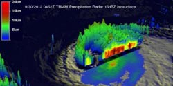
TRMM satellite data from Sept. 30 were used to make this 3-D view of Nadine from the northeast. Convective thunderstorms appear in the northwestern part of the hurricane were reaching to heights of about 12km (~7.5 miles).<br><br>Credit: SSAI/Hal Pierce<br>
Over the weekend of Sept. 29 and 30, Hurricane Nadine dramatically rebounded. On September 19, 2012 Nadine appeared to be dissipating quickly and was expected to become post-tropical but after over a week of meandering near the Azores, Nadine sprang to life again as a hurricane on Friday September 28, 2012.
NASA's Tropical Rainfall Measuring Mission (TRMM) satellite's path took it almost directly above hurricane Nadine on Sept. 30 at 0452 UTC (12:52 a.m. EDT) when it was still a hurricane.
At NASA's Goddard Space Flight Center in Greenbelt, Md. an enhanced infrared image from TRMM's Visible and InfraRed Scanner (VIRS) was overlaid with a rainfall analysis derived from TRMM's TRMM Microwave Imager (TMI) and Precipitation Radar (PR). The final image revealed that Nadine had a well-defined but ragged eye with the heaviest rainfall of about 50mm/hour (~2 inches) located on the western side of the hurricane.
TRMM PR data were used to also create a 3-D view from the northeast that showed convective thunderstorms in the northwestern part of the hurricane were reaching to heights of about 12km (~7.5 miles).
On Oct. 1 at 11 a.m. EDT, the center of Tropical Storm Nadine was 690 miles (1,110 km) west of the Azores near latitude 35.8 north and longitude 39.2 west. Maximum sustained winds have decreased to near 70 mph (110 kph). Nadine is moving toward the south-southeast near 5 mph (7 kph) and expected to do a counter-clockwise loop over the next day, turning southeast and east.
A Tropical Storm Watch is again in effect for the Azores.
Satellite data reveals that the strongest thunderstorms within Nadine are in the northern and eastern quadrants. Wind shear is increasing and sea surface temperatures are below the 80 degree Fahrenheit (26.6 Celsius) threshold needed to keep a tropical storm going, so weakening is expected.
Infrared imagery from NASA's Atmospheric Infrared Sounder (AIRS) instrument aboard the Aqua satellite show that sea surface temperatures near Nadine are around 23 Celsius (73.4 Fahrenheit), too cold to maintain a tropical storm.
According to the National Hurricane Center, tropical storm conditions are possible in the Azores by late Wednesday, Oct. 3.
Media Contact
More Information:
http://www.nasa.govAll latest news from the category: Earth Sciences
Earth Sciences (also referred to as Geosciences), which deals with basic issues surrounding our planet, plays a vital role in the area of energy and raw materials supply.
Earth Sciences comprises subjects such as geology, geography, geological informatics, paleontology, mineralogy, petrography, crystallography, geophysics, geodesy, glaciology, cartography, photogrammetry, meteorology and seismology, early-warning systems, earthquake research and polar research.


Newest articles

High-energy-density aqueous battery based on halogen multi-electron transfer
Traditional non-aqueous lithium-ion batteries have a high energy density, but their safety is compromised due to the flammable organic electrolytes they utilize. Aqueous batteries use water as the solvent for…

First-ever combined heart pump and pig kidney transplant
…gives new hope to patient with terminal illness. Surgeons at NYU Langone Health performed the first-ever combined mechanical heart pump and gene-edited pig kidney transplant surgery in a 54-year-old woman…

Biophysics: Testing how well biomarkers work
LMU researchers have developed a method to determine how reliably target proteins can be labeled using super-resolution fluorescence microscopy. Modern microscopy techniques make it possible to examine the inner workings…

