NASA sees massive rainfall totals from Tropical Storm Oswald
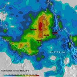
This TRMM satellite rainfall analysis covers the period from Jan. 15-22, 2013. The analysis showed that Oswald and its remnants have already dropped over 600 mm (~23.6 inches) of rain in areas of the Cape York Peninsula near the Gulf of Carpentaria.<br><br>Credit: NASA/SSAI, Hal Pierce<br>
Tropical cyclone Oswald's sustained winds have never been greater than 35 knots (~40.2 mph) but the storm's extreme rainfall has resulted in widespread flooding in Australia over northern Queensland. Many roads have been reported flooded resulting in some communities being cut off.
NASA's Tropical Rainfall Measuring Mission (TRMM) is a satellite that can measure rainfall from space. TRMM-based satellite precipitation estimates are created at NASA's Goddard Space Flight Center in Greenbelt, Md. within about seven hours of observation time. Hal Pierce of NASA Goddard created a rainfall image from a Multi-satellite Precipitation Analysis (MPA) for the period from January 15 to 22, 2013. The analysis showed that Oswald and its remnants had dropped over 600 mm (~23.6 inches) of rain in areas of the Cape York Peninsula near the Gulf of Carpentaria.
According to a report on news.com.au, travelers were requested to cancel plans to go to the Cape York Peninsula, Queensland. Many rivers have flooded and dirt roads are mired in mud over a distance of 560 kilometers (348 miles) that stretch from Laura to Bamaga. Rainfall totals over the Cape York Peninsula to Cardwell were as high as 200mm (7.8 inches) to 300 mm (11.8 inches), which fell south of the town of Innisfail.
For Oswald's storm history, visit NASA's Hurricane page: http://www.nasa.gov/mission_pages/hurricanes/archives/2013/h2013_Oswald.html
Media Contact
More Information:
http://www.nasa.govAll latest news from the category: Earth Sciences
Earth Sciences (also referred to as Geosciences), which deals with basic issues surrounding our planet, plays a vital role in the area of energy and raw materials supply.
Earth Sciences comprises subjects such as geology, geography, geological informatics, paleontology, mineralogy, petrography, crystallography, geophysics, geodesy, glaciology, cartography, photogrammetry, meteorology and seismology, early-warning systems, earthquake research and polar research.


Newest articles

Machine learning algorithm reveals long-theorized glass phase in crystal
Scientists have found evidence of an elusive, glassy phase of matter that emerges when a crystal’s perfect internal pattern is disrupted. X-ray technology and machine learning converge to shed light…

Mapping plant functional diversity from space
HKU ecologists revolutionize ecosystem monitoring with novel field-satellite integration. An international team of researchers, led by Professor Jin WU from the School of Biological Sciences at The University of Hong…

Inverters with constant full load capability
…enable an increase in the performance of electric drives. Overheating components significantly limit the performance of drivetrains in electric vehicles. Inverters in particular are subject to a high thermal load,…

