NASA Sees Large Decrease in Cyclone Sandra's Rainfall Intensity
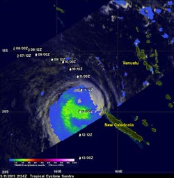
TRMM's Microwave Imager (TMI) data showed Sandra's rainfall on March 11, 2013 at 2124 UTC. Moderate rainfall appears in green. Sandra's previous and forecast locations are shown overlaid in white on this rainfall analysis. NASA/SSAI, Hal Pierce <br>
On March 11, 2013, NASA's TRMM satellite twice flew above weakening tropical cyclone Sandra as it was passing to the west of New Caledonia in the southern Pacific Ocean.
TRMM's Precipitation Radar (PR) had a very good view of Sandra as it passed directly above the tropical cyclone on March 11 at 1312 UTC (9:12 a.m. EST). TRMM PR measured rainfall at the extreme rate of over 206 mm (~8 inches) per hour in an area southwest of Sandra's eye. Those TRMM PR data also showed that very little rain was occurring north of the weakening tropical cyclone's eye.
New Caledonia escaped the heaviest precipitation as the center of Sandra remained off-shore.
Later on that day at 2124 UTC (4:24 p.m. EDT), TRMM's Microwave Imager (TMI) data identified diminished rainfall rates. The heaviest rains occurring south of Sandra's center at that time was falling at a rate of 30 mm (1.18 in) per hour. Wind shear continues to increase from the north and push the precipitation south of Sandra's center. Sandra's center has since become fully exposed to outside winds as the intensity of rainfall has diminished.
On Mar. 13 at 0300 UTC, Sandra's maximum sustained winds were near 55 knots (63.2 mph/101.9 kph). Sandra was located near 24.1 south and 161.5 east, about 270 nautical miles (310.7 miles/500 km ) west-southwest of Noumea, New Caledonia. Sandra was moving to the south-southwest at 8 knots (9.2 mph/14.8 kph).
Sandra is moving into an area of high vertical wind shear and colder sea surface temperatures that are expected to make the storm transform into a cold-core system before it dissipates over the next couple of days.
Text credit: Rob Gutro
NASA's Goddard Space Flight Center, Greenbelt, Md.
Media Contact
All latest news from the category: Earth Sciences
Earth Sciences (also referred to as Geosciences), which deals with basic issues surrounding our planet, plays a vital role in the area of energy and raw materials supply.
Earth Sciences comprises subjects such as geology, geography, geological informatics, paleontology, mineralogy, petrography, crystallography, geophysics, geodesy, glaciology, cartography, photogrammetry, meteorology and seismology, early-warning systems, earthquake research and polar research.


Newest articles

“Nanostitches” enable lighter and tougher composite materials
In research that may lead to next-generation airplanes and spacecraft, MIT engineers used carbon nanotubes to prevent cracking in multilayered composites. To save on fuel and reduce aircraft emissions, engineers…

Trash to treasure
Researchers turn metal waste into catalyst for hydrogen. Scientists have found a way to transform metal waste into a highly efficient catalyst to make hydrogen from water, a discovery that…

Real-time detection of infectious disease viruses
… by searching for molecular fingerprinting. A research team consisting of Professor Kyoung-Duck Park and Taeyoung Moon and Huitae Joo, PhD candidates, from the Department of Physics at Pohang University…

