NASA Sees Hurricane Raymond Re-Soaking Mexican Coast
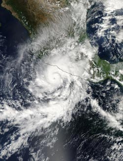
On Oct. 21 at 20:10 UTC/4:10 p.m. EDT, NASA's Aqua satellite captured this image of Hurricane Raymond battering the southwestern coast of Mexico. <br>Image Credit: NASA Goddard MODIS Rapid Response Team <br>
The Tropical Rainfall Measuring Mission or TRMM satellite flew directly above hurricane Raymond on Oct. 21 at 0111 UTC/Oct. 20 at 6:11 p.m. PDT). TRMM Precipitation Radar (PR) data from that orbit shows that Hurricane Raymond contained towering thunderstorms on the western side of the eye wall that were reaching to heights above 15 km/~9.3 miles.
TRMM PR also recorded precipitation in Raymond's eye wall that was falling at a rate of over 153 mm/~5.6 inches per hour and returning radar reflectivity values greater than 53dBZ to the satellite. Rain was shown by TRMM to be falling at a rate of over 30 mm /~1.2 inches per hour along Mexico's coast.
On Oct. 22, the heavy rain continued along the southwestern coast of Mexico, and warnings were still in effect. The following warnings and watches were in effect on Oct. 22, according to the National Hurricane Center (NHC): a Hurricane Warning is in effect for Tecpan de Galeana to Lazaro Cardenas; a Hurricane Watch is in effect for Acapulco to Tecpan de Galeana; and a Tropical Storm Warning is in effect for Acapulco to Tecpan de Galeana.
In short, what those warnings mean is hurricane-force and tropical-storm-force winds in the warning areas, accompanied by heavy rainfall, dangerous storm surges, riptides, heavy surf, and coastal flooding.
The heavy rainfall that TRMM observed is affecting the coast. The National Hurricane Center expects Raymond to generate between 4 and 8 inches with isolated totals up to 12 inches over the Mexican states of Guerrero and Michoachan. As with rainfall this heavy, flash flooding and mudslides can occur.
As of 8 a.m. EDT on Oct. 22, a weather station near Acapulco, Mexico reported 7.63 inches/194 mm of rain in the previous 48 hours and it was still raining.
By 11 a.m. EDT, Raymond's maximum sustained winds were near 105 mph/165 kph. Raymond's center was located near latitude 16.5 north and longitude 101.9 west. That puts the center of the storm about 85 miles/135 km south-southwest of Zihuatanejo and 135 miles/220 km west-southwest of Acapulco. Raymond was stationary for hours during the morning of Oct. 22, and the storm is expected to move slowly and erratically, and possibly closer to the coast before moving west-southwest on Oct. 23.
Text credit: Hal Pierce/Rob Gutro
SSAI/NASA's Goddard Space Flight Center
Media Contact
All latest news from the category: Earth Sciences
Earth Sciences (also referred to as Geosciences), which deals with basic issues surrounding our planet, plays a vital role in the area of energy and raw materials supply.
Earth Sciences comprises subjects such as geology, geography, geological informatics, paleontology, mineralogy, petrography, crystallography, geophysics, geodesy, glaciology, cartography, photogrammetry, meteorology and seismology, early-warning systems, earthquake research and polar research.


Newest articles

Silicon Carbide Innovation Alliance to drive industrial-scale semiconductor work
Known for its ability to withstand extreme environments and high voltages, silicon carbide (SiC) is a semiconducting material made up of silicon and carbon atoms arranged into crystals that is…

New SPECT/CT technique shows impressive biomarker identification
…offers increased access for prostate cancer patients. A novel SPECT/CT acquisition method can accurately detect radiopharmaceutical biodistribution in a convenient manner for prostate cancer patients, opening the door for more…

How 3D printers can give robots a soft touch
Soft skin coverings and touch sensors have emerged as a promising feature for robots that are both safer and more intuitive for human interaction, but they are expensive and difficult…

