NASA sees Hurricane Lane punched in the eye
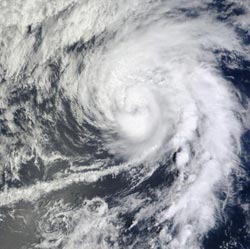
When NASA's Terra satellite passed over the Eastern Pacific on Sept. 17 at 3:25 p.m. EDT the satellite captured a close-up of Hurricane Lane. Lane's eye appears obscured by clouds, and towering thunderstorms are wrapped tightly around the center of circulation.<br><br>Credit: NASA Goddard MODIS Rapid Response Team<br>
The Moderate Resolution Imaging Spectroradiometer (MODIS) instrument captured a close-up of Lane on Sept. 17 at 3:25 p.m. EDT when it was still a hurricane. In the image, Lane's eye appeared obscured by clouds as towering thunderstorms wrapped tightly around the center of circulation.
By Tuesday, Sept. 18 at 11 a.m. EDT, Lane weakened to a tropical storm. Lane's maximum sustained winds had fallen to 70 mph (110 kmh). It was centered about 1,170 miles (1,885 km) west of the southern tip of Baja California, near 20.1 North latitude and 127.9 West longitude. It was moving to the north near 9 mph (15 kmh) and is expected to turn to the northwest.
Those towering cloud tops surrounding Lane's entire eye had warmed on Tuesday, Sept. 18, indicating that they are not as high, and weaker.
Forecasters at the National Hurricane Center expect that Lane will be punched all over, not just “in the eye.” There are two factors that are giving Lane a beating on Sept. 18 and 19, and those are cooler waters and increased wind shear. Lane is moving into an area where sea surface temperatures are colder than 22 Celsius (71.6 Fahrenheit), far below the 26.6C (80F) threshold needed for keeping a tropical cyclone alive. In addition, wind shear is forecast to increase from the southwest and pummel Lane at speeds of 25 knots (28.7 mph/46.3 kph), eventually “knocking it out.” Lane is expected to become a remnant low pressure area by Wed., Sept. 19.
Media Contact
More Information:
http://www.nasa.govAll latest news from the category: Earth Sciences
Earth Sciences (also referred to as Geosciences), which deals with basic issues surrounding our planet, plays a vital role in the area of energy and raw materials supply.
Earth Sciences comprises subjects such as geology, geography, geological informatics, paleontology, mineralogy, petrography, crystallography, geophysics, geodesy, glaciology, cartography, photogrammetry, meteorology and seismology, early-warning systems, earthquake research and polar research.


Newest articles

Octopus inspires new suction mechanism for robots
A new robotic suction cup which can grasp rough, curved and heavy stone, has been developed by scientists at the University of Bristol. The team, based at Bristol Robotics Laboratory,…

Peptides on Interstellar Ice
A research team led by Dr Serge Krasnokutski from the Astrophysics Laboratory at the Max Planck Institute for Astronomy at the University of Jena had already demonstrated that simple peptides…

A new look at the consequences of light pollution
GAME 2024 begins its experiments in eight countries. Can artificial light at night harm marine algae and impair their important functions for coastal ecosystems? This year’s project of the training…

