NASA sees Hurricane Hilary's heaviest rain in northwest quadrant
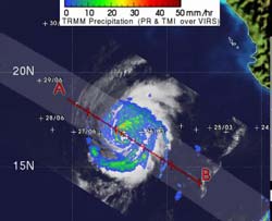
Hurricane Hilary's heaviest rainfall was occurring in its northwestern quadrant where rain was falling at 2 inches (50 mm) per hour (red). Around the rest of the storm was mostly moderate to light rainfall (green and blue) between .78 to 1.57 inches (20 to 40 mm) per hour. Credit: NASA/SSAI, Hal Pierce<br>
NASA's Tropical Rainfall Measuring Mission satellite known as TRMM passed over Hilary on Sept. 26 at 5:29 a.m. EDT and its precipitation radar instrument measured rainfall happening throughout the storm from its orbit in space. TRMM saw that most of the rainfall occurring in Hurricane Hilary today was moderate, and the heaviest area was limited to its northwestern quadrant where rain was coming down at 2 inches/50 mm per hour.
TRMM also has the ability to measure cloud heights, which indicate the power within a hurricane. The higher the towering clouds around the eye, usually the stronger the power within the hurricane. TRMM noticed that the highest cumulonimbus (thunderstorm) clouds in the center were around 14 kilometers (8.6 miles). Towering clouds that height are indicative of a lot of power in the storm.
At 5 a.m. EDT (2 a.m. PDT) on Sept. 26, Hilary's maximum sustained winds were near 120 mph (195 kmh). It was centered near 16.9 North and 112.2 West, about 440 miles (710 km) south-southwest of the southern tip of Baja California. It is moving away from Mexico to the west at 10 mph (17 kmh) and has a minimum central pressure of 959 millibars.
Hilary is going through some changes today. It appears slightly elongated today from north to south. Cloud top temperatures in infrared satellite imagery indicate that her cloud tops are cooling, indicating they're going higher (and getting stronger).
The National Hurricane Center forecast calls for Hilary to change course and take a northeastern track, coming close to Baja California by the end of the week, but as a depression. Forecasters and NASA satellites are keeping a close eye on Hilary this week.
Media Contact
More Information:
http://www.nasa.govAll latest news from the category: Earth Sciences
Earth Sciences (also referred to as Geosciences), which deals with basic issues surrounding our planet, plays a vital role in the area of energy and raw materials supply.
Earth Sciences comprises subjects such as geology, geography, geological informatics, paleontology, mineralogy, petrography, crystallography, geophysics, geodesy, glaciology, cartography, photogrammetry, meteorology and seismology, early-warning systems, earthquake research and polar research.


Newest articles

Superradiant atoms could push the boundaries of how precisely time can be measured
Superradiant atoms can help us measure time more precisely than ever. In a new study, researchers from the University of Copenhagen present a new method for measuring the time interval,…

Ion thermoelectric conversion devices for near room temperature
The electrode sheet of the thermoelectric device consists of ionic hydrogel, which is sandwiched between the electrodes to form, and the Prussian blue on the electrode undergoes a redox reaction…

Zap Energy achieves 37-million-degree temperatures in a compact device
New publication reports record electron temperatures for a small-scale, sheared-flow-stabilized Z-pinch fusion device. In the nine decades since humans first produced fusion reactions, only a few fusion technologies have demonstrated…

