NASA Sees Hurricane Barbara Quickly Weaken to a Depression
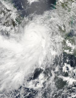
The MODIS instrument aboard NASA’s Aqua satellite captured this visible image of Hurricane Barbara as it was making landfall in southwestern Mexico. The image was taken at 19:30 UTC (3:30 p.m. EDT). Credit: NASA Goddard MODIS Rapid Response Team <br>
Barbara is moving across the Isthmus of Tehuantepec today, May 30. Barbara could regenerate over the Bay of Campeche, on the Gulf of Mexico side of Mexico, and satellite imagery is watching Barbara closely. The Bay of Campeche is surrounded on three sides by the Mexican states of Campeche, Veracruz and Tabasco and is part of the Gulf of Mexico.
At 2 p.m. EDT on May 29, Barbara became a hurricane with maximum sustained winds near 75 mph. Just three hours later Barbara was already moving over land. It brought heavy rainfall to eastern Oaxaca and Western Chiapas, Mexico.
The MODIS instrument aboard NASA’s Aqua satellite captured a visible image of Hurricane Barbara as it was making landfall in southwestern Mexico. The image was taken at 19:30 UTC (3:30 p.m. EDT). The image showed a large “tail” of thunderstorms that extended into the eastern Pacific Ocean.
By 8 p.m. EDT Barbara weakened back to tropical storm status as maximum sustained winds dropped to 60 mph. At 11 p.m. EDT, Barbara, still a tropical storm, although weaker was dropping a lot of rain. It was located near 17.1 north and 93.8 west, about 50 miles (85 km) west-northwest of Tuxtla Gutierrez, Mexico.
The Atmospheric Infrared Sounder (AIRS) instrument that flies aboard NASA’s Aqua satellite captured infrared images of Barbara’s cloud top temperatures on May 29 and May 30. The images showed that the interaction with landfall had a large toll on the organization and uplift of air within the storm. In an image from May 29 at 19:23 UTC (3:23 p.m. EDT) Barbara contained a large area of powerful thunderstorms, where cloud top temperatures were as cold as -63F (-52C). Those storms had the potential for heavy rainfall. After Barbara made landfall, AIRS captured another infrared image that showed how the friction of Barbara’s land interaction drastically reduced the uplift and thunderstorm development as cloud top temperatures warmed. The AIRS image, taken on May 30 at 07:35 UTC (3:35 a.m. EDT) showed fragmented strong thunderstorms around the center of circulation, with the largest area over the Gulf of Campeche.
By 5 a.m. EDT on May 30, Barbara weakened to a tropical depression with maximum sustained winds near 35 mph (55 kph). It was centered near 17.8 north and 93.9 west, about 40 miles (60 km) southeast of Coatzacoalcos, Mexico. Barbara is moving to the north at 8 mph (13 kph) and has a minimum central pressure of 1000 millibars. At that time, there were no warnings or watches in effect.
Barbara continues to be a big rainmaker over land. The National Hurricane Center (NHC) expects Barbara to produce total rain accumulations of 6 to 10 inches with isolated maximum amounts of 20 inches possible over portions of southeastern Mexico. The NHC reports that Arriaga, located in the State of Chiapas recorded a rainfall total of 16.02 inches (407 mm) in 18 hours from 11 a.m. EDT on May 29 to 5 a.m. EDT, May 30.
The Independent.ie reported that two people were killed as a result of the storm. A 26 year old Mexican resident was killed in an attempt to cross a rain swelled river and a 61-year-old U.S. man who was surfing at a Salina Cruz beach drowned during the storm.
The National Hurricane Center expects Barbara to keep dropping large amounts of rain over portions of southeastern Mexico today, May 30 as it heads for the Bay of Campeche. Barbara is expected to drop between 6 and 10 inches of rainfall with isolated maximum amounts up to 20 inches today, so inland flooding and mudslides are possible.
Text credit: Rob Gutro
NASA’s Goddard Space Flight Center
Media Contact
All latest news from the category: Earth Sciences
Earth Sciences (also referred to as Geosciences), which deals with basic issues surrounding our planet, plays a vital role in the area of energy and raw materials supply.
Earth Sciences comprises subjects such as geology, geography, geological informatics, paleontology, mineralogy, petrography, crystallography, geophysics, geodesy, glaciology, cartography, photogrammetry, meteorology and seismology, early-warning systems, earthquake research and polar research.


Newest articles

Properties of new materials for microchips
… can now be measured well. Reseachers of Delft University of Technology demonstrated measuring performance properties of ultrathin silicon membranes. Making ever smaller and more powerful chips requires new ultrathin…

Floating solar’s potential
… to support sustainable development by addressing climate, water, and energy goals holistically. A new study published this week in Nature Energy raises the potential for floating solar photovoltaics (FPV)…

Skyrmions move at record speeds
… a step towards the computing of the future. An international research team led by scientists from the CNRS1 has discovered that the magnetic nanobubbles2 known as skyrmions can be…

