NASA sees very heavy rainfall within Tropical Storm Ernesto
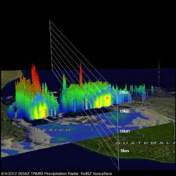
NASA's TRMM satellite saw tropical storm Ernesto on Aug. 9, 2012, at 0656 UTC. This 3-D view of Ernesto's vertical structures shows some powerful convective storms near Ernesto's center were pushing to heights of over 16 kilometers (~9.94 miles).<br><br>Credit: NASA/SSAI, Hal Pierce<br>
The TRMM satellite saw tropical storm Ernesto on August 9, 2012 at 0656 UTC (2:36 a.m. EDT) after it moved from the Yucatan Peninsula into the Gulf of Mexico. An analysis of TRMM Microwave Imager (TMI) and Precipitation Radar (PR) rainfall shows that powerful convective thunderstorms were dropping rain at a rate greater than 50mm per hour (~2 inches) north of the storm's center.
TRMM Precipitation Radar (PR) data were used to create a 3-D view of Ernesto's vertical structure. The PR view shows that a few of the powerful convective storms near Ernesto's center were pushing to heights of over 16 kilometers (~9.94 miles). The energy released by these storms near Ernesto's center can be a sign of intensification.
At 10 a.m. EDT on August 9, the National Hurricane Center noted that Ernesto's center was located very close to the coast, or already on land, near 18.2 North and 94.3 West. Ernesto's maximum sustained winds are near 60 mph (95 kmh) with higher gusts, but as Ernesto moves inland it is expected to weaken. Ernesto is moving west near 10 mph (17 kmh) and will move over southern Mexico over the next two days.
A Tropical Storm Warning is in effect from Veracruz to Chilitepec today, August 9. The National Hurricane Center expects the heavy rainfall that NASA's TRMM satellite identified to bring between five to 10 inches of rain, locally up to 15 inches, over the Mexican states of Tabasco, Veracruz, Puebla and Oaxaca. Flash floods and mudslides are a concern with these large amounts of rainfall. In addition another one to two inches of rain are possible over northern Guatemala and the southwestern Yucatan Peninsula.
A visible image of Tropical Storm Ernesto was captured from the Moderate Resolution Imaging Spectroradiometer (MODIS) instrument on NASA's Terra satellite, on August 8, when it was over the Yucatan Peninsula, and before it emerged into the Gulf of Mexico. To see that image, visit: http://tinyurl.com/9cuufa7
Media Contact
More Information:
http://www.nasa.govAll latest news from the category: Earth Sciences
Earth Sciences (also referred to as Geosciences), which deals with basic issues surrounding our planet, plays a vital role in the area of energy and raw materials supply.
Earth Sciences comprises subjects such as geology, geography, geological informatics, paleontology, mineralogy, petrography, crystallography, geophysics, geodesy, glaciology, cartography, photogrammetry, meteorology and seismology, early-warning systems, earthquake research and polar research.


Newest articles

Machine learning algorithm reveals long-theorized glass phase in crystal
Scientists have found evidence of an elusive, glassy phase of matter that emerges when a crystal’s perfect internal pattern is disrupted. X-ray technology and machine learning converge to shed light…

Mapping plant functional diversity from space
HKU ecologists revolutionize ecosystem monitoring with novel field-satellite integration. An international team of researchers, led by Professor Jin WU from the School of Biological Sciences at The University of Hong…

Inverters with constant full load capability
…enable an increase in the performance of electric drives. Overheating components significantly limit the performance of drivetrains in electric vehicles. Inverters in particular are subject to a high thermal load,…

