NASA sees heavy rainfall in Super Typhoon Soudelor
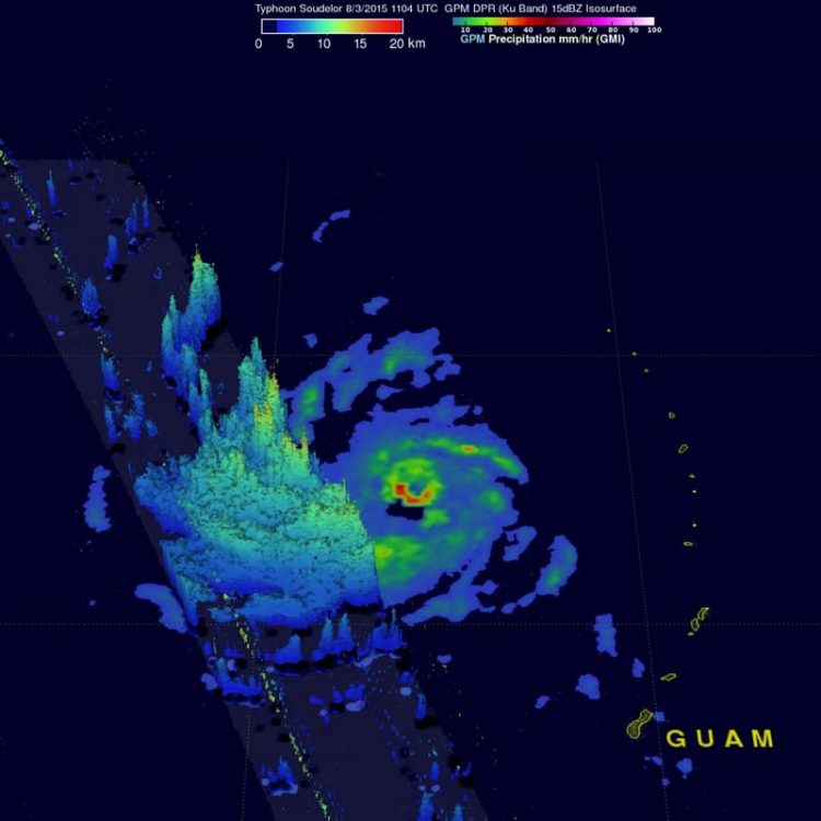
On Aug. 3, 2015, the GPM Core Observatory saw Soudelor had rain falling at a rate of over 58 mm (2.3 inches) per hour in the southern side of the well-defined eye. Credits: NASA, Hal Pierce/JAXA
The Global Precipitation Measurement (GPM) core observatory satellite flew almost directly over Super Typhoon Soudelor in the western Pacific Ocean on Aug. 3, 2015, at 1104 UTC (7:04 a.m. EDT). GPM is managed by NASA and the Japan Aerospace Exploration Agency.
At the time GPM passed overhead, Super Typhoon Soudelor had winds of about 125 knots (139 mph) and is predicted by the Joint Typhoon Warning Center (JTWC) to become even more powerful tomorrow, Aug. 4, while headed toward northern Taiwan.
GPM's Microwave Imager (GMI) had a very good view of heavy rainfall associated with Soudelor. GMI showed that the super typhoon had rain falling at a rate of over 58 mm (2.3 inches) per hour in the southern side of Soudelor's well defined eye. Radar Reflectivity measured by GPM's Dual-Frequency Precipitation Radar (DPR) instrument (Ku band) were used to show a 3-D cross section through Soudelor's western side.
At 1500 UTC (11 a.m. EDT) on Aug. 3, Super typhoon Soudelor's maximum sustained winds increased to 135 knots (155.4 mph/250 kph). Typhoon-force winds were compact, extending 30 miles from the center. It was centered near 16.9 North latitude and 142. 9 East longitude, about 268 nautical miles (308 miles/496.3 km) west-northwest of Saipan. It was moving to the west-northwest at 12 knots (13.8 mph/22.2 kph).
The Joint Typhoon Warning Center noted that Soudelor is expected to further intensify and will peak at 150 knots later in the day today, Aug. 4. The storm is expected to gradually weaken as it nears Taiwan in 4 days' time, making final landfall in eastern China.
Media Contact
All latest news from the category: Earth Sciences
Earth Sciences (also referred to as Geosciences), which deals with basic issues surrounding our planet, plays a vital role in the area of energy and raw materials supply.
Earth Sciences comprises subjects such as geology, geography, geological informatics, paleontology, mineralogy, petrography, crystallography, geophysics, geodesy, glaciology, cartography, photogrammetry, meteorology and seismology, early-warning systems, earthquake research and polar research.


Newest articles

Superradiant atoms could push the boundaries of how precisely time can be measured
Superradiant atoms can help us measure time more precisely than ever. In a new study, researchers from the University of Copenhagen present a new method for measuring the time interval,…

Ion thermoelectric conversion devices for near room temperature
The electrode sheet of the thermoelectric device consists of ionic hydrogel, which is sandwiched between the electrodes to form, and the Prussian blue on the electrode undergoes a redox reaction…

Zap Energy achieves 37-million-degree temperatures in a compact device
New publication reports record electron temperatures for a small-scale, sheared-flow-stabilized Z-pinch fusion device. In the nine decades since humans first produced fusion reactions, only a few fusion technologies have demonstrated…

