NASA sees heavy rain in Tropical Cyclone Lam
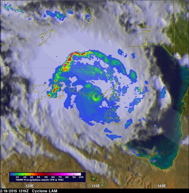
The TRMM satellite saw rainfall in Lam was occurring at 123 mm (4.8 inches) per hour in an intense band of storms over the Timor Sea northwest of the eye. Some thunderstorms topped over 16.7 km (10.4 miles). Image Credit: NASA/JAXA, Hal Pierce
Tropical Cyclone Lam made landfall as a Category Four storm, according to the Australian Bureau of Meteorology (ABM). It came ashore near Elcho and Goulburn Island, east of Darwin.
TRMM passed over Lam on Feb. 19 at 13:19 UTC (8:19 a.m. EST). TRMM's Precipitation Radar (PR) had just been temporarily returned to service when it passed over Lam. The PR instrument found rain falling at an estimated rate of over 123 mm (4.8 inches) per hour in an intense band of storms over the Timor Sea northwest of LAM's eye. Some thunderstorm tops in that area were found reaching heights of over 16.7 km (10.4 miles).
As of Feb. 20, the ABM cancelled the cyclone warning for inland parts of the central Arnhem District. At 4:00 p.m. CST Darwin local time, Lam's sustained winds were near 55 kph.
Lam was centered near 14.1 degrees south and 133.8 degrees east, about 75 km southwest of Bulman, Northern Territory. Lam was speeding to the south-southwest at 21 kph.
ABM noted “Squally thunderstorms are likely to continue over the Top End. Heavy rain is expected to cause flooding of low-lying areas and cause river rises over the central Top End. A Flood Watch for the Arnhem and Carpentaria Coastal Rivers has been issued.” For further updates on local conditions visit the ABM website: http://www.
The TRMM satellite is managed by both NASA and the Japan Aerospace Exploration Agency.
Media Contact
All latest news from the category: Earth Sciences
Earth Sciences (also referred to as Geosciences), which deals with basic issues surrounding our planet, plays a vital role in the area of energy and raw materials supply.
Earth Sciences comprises subjects such as geology, geography, geological informatics, paleontology, mineralogy, petrography, crystallography, geophysics, geodesy, glaciology, cartography, photogrammetry, meteorology and seismology, early-warning systems, earthquake research and polar research.


Newest articles

Properties of new materials for microchips
… can now be measured well. Reseachers of Delft University of Technology demonstrated measuring performance properties of ultrathin silicon membranes. Making ever smaller and more powerful chips requires new ultrathin…

Floating solar’s potential
… to support sustainable development by addressing climate, water, and energy goals holistically. A new study published this week in Nature Energy raises the potential for floating solar photovoltaics (FPV)…

Skyrmions move at record speeds
… a step towards the computing of the future. An international research team led by scientists from the CNRS1 has discovered that the magnetic nanobubbles2 known as skyrmions can be…

