NASA sees ex-Tropical Cyclone Gillian in Australia's Gulf of Carpentaria
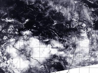
On March 12, the VIIRS instrument aboard NASA-NOAA's Suomi NPP satellite captured this image of the remnants of Tropical Cyclone Gillian in the Gulf of Carpentaria. Credit: NRL/NASA/NOAA
On March 12 at 0600 UTC/2 a.m. EST, the remnants of Tropical Cyclone Gillian were located near 16.0 south and 141.1 east, about 115 nautical miles/ 132.3 miles/213 km east-northeast of Mornington Island in the Gulf of Carpentaria.
According to the Joint Typhoon Warning Center or JTWC maximum sustained surface winds were estimated between 15 to 20 knots/17.2 to 23.0 mph/27.7 to 37.0 kph. Minimum sea level pressure is estimated to be near 1008 millibars.
NASA-NOAA's Suomi NPP satellite passed over the remnants of Tropical Cyclone Gillian on March 12 and the Visible Infrared Imaging Radiometer Suite or VIIRS instrument aboard captured a high-resolution visible image of the storm. Satellite imagery indicated that the low-level center of circulation appeared elongated.
VIIRS is a scanning radiometer that collects visible and infrared imagery and radiometric measurements. VIIRS data is used to measure cloud and aerosol properties, ocean color, sea and land surface temperature, ice motion and temperature, fires, and Earth's albedo.
The Joint Typhoon Warning Center noted that animated multispectral satellite imagery on March 13 showed that the low-level circulation center of the low pressure area was weak, and that there was isolated deep convection northeast of the center, indicative of wind shear.
The Australian Bureau of Meteorology (ABM) noted that Gillian's remnants were moving slowly west over the southern Gulf of Carpentaria. The low is expected to continue moving west on Thursday, March 13 before moving northwest across the Gulf of Carpentaria on Friday, March 14. For ABM updated watches and warnings, visit: http://www.bom.gov.au/cyclone.
The Joint Typhoon Warning Center noted that Gillian has a low chance for becoming a significant tropical cyclone within the next day.
Media Contact
More Information:
http://www.nasa.govAll latest news from the category: Earth Sciences
Earth Sciences (also referred to as Geosciences), which deals with basic issues surrounding our planet, plays a vital role in the area of energy and raw materials supply.
Earth Sciences comprises subjects such as geology, geography, geological informatics, paleontology, mineralogy, petrography, crystallography, geophysics, geodesy, glaciology, cartography, photogrammetry, meteorology and seismology, early-warning systems, earthquake research and polar research.


Newest articles

Silicon Carbide Innovation Alliance to drive industrial-scale semiconductor work
Known for its ability to withstand extreme environments and high voltages, silicon carbide (SiC) is a semiconducting material made up of silicon and carbon atoms arranged into crystals that is…

New SPECT/CT technique shows impressive biomarker identification
…offers increased access for prostate cancer patients. A novel SPECT/CT acquisition method can accurately detect radiopharmaceutical biodistribution in a convenient manner for prostate cancer patients, opening the door for more…

How 3D printers can give robots a soft touch
Soft skin coverings and touch sensors have emerged as a promising feature for robots that are both safer and more intuitive for human interaction, but they are expensive and difficult…

